
Install the app
How to install the app on iOS
Follow along with the video below to see how to install our site as a web app on your home screen.

Note: This feature currently requires accessing the site using the built-in Safari browser.
-
New here? Register here now for access to all the forums, download game torrents, private messages, polls, Sportsbook, etc. Plus, stay connected and follow BP on Instagram @buckeyeplanet and Facebook.
You are using an out of date browser. It may not display this or other websites correctly.
You should upgrade or use an alternative browser.
You should upgrade or use an alternative browser.
This is getting old....really!
- Thread starter Gatorubet
- Start date

Gatorubet
Loathing All Things Georgia
Nutriaitch;1239893; said:Track moving eastward now. If it goes this direction, I'll be on the "good" side of it. But where it's supposed to be Monday AM is only a couple hundred miles from me at most, so that leaves very little room for error.

I dunno man...looks like it is still in the air to me.
Upvote
0
Nutriaitch
Retired Super Hero
Gatorubet;1239995; said:I dunno man...looks like it is still in the air to me.
Not what I wanted to see.
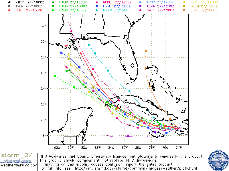
The red asterisk I added to the pic is roughly where I'm located.
Upvote
0
Gatorubet
Loathing All Things Georgia
[quote='BusNative;124003;6]Stay safe, fellas.[/quote]
Thanks. FWIW, I like this link below (in addition to wunderground.com) to check what's up during Hurricane season.
GOLDEN TRIANGLE WEATHER PAGE
Thanks. FWIW, I like this link below (in addition to wunderground.com) to check what's up during Hurricane season.
GOLDEN TRIANGLE WEATHER PAGE
Upvote
0
bkochmc
Assistant Coach
Wow, that site is... thorough.Gatorubet;1240040; said:Thanks. FWIW, I like this link below (in addition to wunderground.com) to check what's up during Hurricane season.
GOLDEN TRIANGLE WEATHER PAGE
*bookmarks website*
Upvote
0
Gatorubet
Loathing All Things Georgia
NorthShoreBuck;1239766; said:I'm off to buy cases of beer today. I have plenty of gas, water, food and batteries. Need some LPG for the grill and some ammo. The chain saw and generator are ready. Not sure if I will leave or stay.
New Orleans hosts the decadence festival this weekend, the gay mardi gras, this could get interesting.
Someone somewhere will get hit hard by this one.
FIFY

Upvote
0
LoKyBuckeye
I give up. This board is too hard to understand.
I think we can all agree that we hope it takes a left turn and hits Texas.... if it comes anywhere near us I'll be back at work 24/7 just like for Fay.... 
Upvote
0
NorthShoreBuck
True Madness Requires Significant Intelligence
Gator
I added the 150 qt, 7 day cooler to my collection. You know how much beer that can hold? I can drink water and wine warm, got plenty of that also, but not beer.
The stores were crowded, but everyone seemed relaxed. I am sure as the time of impact approaches that might change. Maybe we will be better prepared this time.
As we frequently say, I do not want to wish bad on anyone else but please have it go anyplace but here.
Upvote
0

daddyphatsacs
Let the cards fall...
Anyone who is in the path of this one should be making preparations. You get the feeling that Gustav will become a household name over the next week or two. With the Gulf being in the mid to upper 80's in water temps, and no major wind shear.........look out. Let's just hope that it moves very quickly after it gets into the open Gulf of Mexico, because I get the feeling that we could be looking at a Major Cat 3, possible Cat 4 on Sunday if not.
Upvote
0
Gatorubet
Loathing All Things Georgia
daddyphatsacs;1240560; said:Anyone who is in the path of this one should be making preparations. You get the feeling that Gustav will become a household name over the next week or two. With the Gulf being in the mid to upper 80's in water temps, and no major wind shear.........look out. Let's just hope that it moves very quickly after it gets into the open Gulf of Mexico, because I get the feeling that we could be looking at a Major Cat 3, possible Cat 4 on Sunday if not.
Don't know if you are familiar with Loop Currents daddy, but this is some good info on a subject that can blow up a weak storm into a bad boy in a hurry!
Gustav's intensification potential in the Gulf of Mexico
As we saw in 2005 with Katrina and Rita, the large amounts of deep, warm water brought into the Gulf of Mexico by the Loop Current can help intensify hurricanes to Category 5 intensity. As explained in my Loop Current tutorial, the Loop Current is an ocean current that transports warm Caribbean water through the Yucatan Channel between Cuba and Mexico. The current flows northward into the Gulf of Mexico, then loops southeastward through the Florida Keys. The Loop Current commonly bulges out in the northern Gulf of Mexico and sometimes will shed a clockwise rotating ring of warm water that separates from the main current. This ring of warm water slowly drifts west-southwestward towards Texas or Mexico at about 3-5 km per day. This feature is called a "Loop Current Ring", "Loop Current Eddy", or "Warm Core Ring", and can provide a key source of energy to fuel rapid intensification of hurricanes that cross the Gulf. The Loop Current itself can also fuel rapid intensification, such as happened with Hurricane Charley in 2004. When a Loop Current Eddy breaks off in the Gulf of Mexico at the height of hurricane season, it can lead to a dangerous situation where a vast reservoir of energy is available to any hurricane that might cross over. This occurred in 2005, when a Loop Current Eddy separated in July, just before Hurricane Katrina passed over and "bombed" into a Category 5 hurricane. The eddy remained in the Gulf and slowly drifted westward during September. Hurricane Rita passed over the same Loop Current Eddy three weeks after Katrina, and also explosively deepened to a Category 5 storm.
This year, we had another Loop Current Eddy break off in July. This eddy is now positioned due south of New Orleans (Figure 2), and this eddy has similar levels of heat energy to the 2005 eddy that powered Katrina and Rita. Should Gustav pass over or just to the left of this eddy, we can expect the storm to significantly intensify. There is also a weaker eddy present in the western Gulf; this eddy broke off from the Loop Current in April, and is much cooler then the eddy that broke off in July. Should Gustav pass over the April eddy, it shouldn't make much difference.
A NOAA Hurricane Hunter research aircraft is scheduled to drop a network of 20 specialized buoys (Air eXpendable BathyThermographs, or AXBTs) in the Gulf of Mexico Thursday to provide precise measurements of ocean temperatures in order to aid intensification forecasts for Gustav. This data will feed directly into the GFDL and HWRF computer models, but not into the other global models (GFS, NOGAPS, UKMET, and ECMWF).

Figure 2.Tropical Cyclone Heat Potential (TCHP) for the Gulf of Mexico on August 24, 2008. TCHP values in excess of 80 kJ/cm^2 (yellow colors) have been found to promote rapid intensification of hurricanes. The Loop Current is shown by the arrows at lower right, and begins in the Caribbean, flows north through the Yucatan Channel into the Gulf of Mexico, then loops back to the south and turns eastward over the Florida Keys. Two Loop Current Eddies have broken off from the Loop Current this year--one in April, and one in July. These eddies have drifted slowly westward, and still maintain heat from the Loop Current. Image credit: NOAA/AOML.
Upvote
0
