• Follow us on Twitter @buckeyeplanet and @bp_recruiting, like us on Facebook! Enjoy a post or article, recommend it to others! BP is only as strong as its community, and we only promote by word of mouth, so share away!
  • Consider registering! Fewer and higher quality ads, no emails you don't want, access to all the forums, download game torrents, private messages, polls, Sportsbook, etc. Even if you just want to lurk, there are a lot of good reasons to register!
2022 could be a turning point in the study of UFOs
By Leonard David published January 21, 2022
Interest in UFOs continues to grow, both among scientists and government officials.
https://www.space.com/2022-turning-point-study-ufos-uap
kTTf7SSpjpaqbaox7kzUkB-970-80.jpg.webp

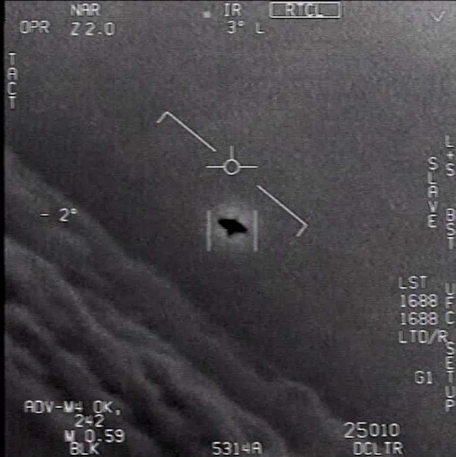
An unidentified flying object captured on video by a U.S. Navy jet. (Image credit: DOD/U.S. Navy)
In 2021, there was an upsurge in peculiar sightings reported, thanks to people with smartphones or other video gear that captured these strange glimmers in the sky.

Could these unidentified aerial phenomena (UAP) be satellites, technology deployed by foreign governments, falling space junk or maybe even floating specialty balloons or purposely faked unidentified flying objects (UFOs)?

Earth has been on the receiving end of extraterrestrials speeding in from Alpha Centauri who found themselves lacking brake fluid and crashed into New Mexico?

Many of these objects are ultimately identified. Others, however, remain mysterious.

Nonetheless, in 2022, UAP will get more attention from both the scientific community and the federal government, experts told Space.com.

In June 2021, the U.S. military and intelligence community issued a report on UAPs. It was followed by congressional urging to establish a formal office to carry out a "coordinated effort" on collection and analysis related to UAP.

"Our national security efforts rely on aerial supremacy, and these phenomena present a challenge to our dominance over the air. Staying ahead of UAP sightings is critical to keeping our strategic edge and keeping our nation safe," Sen. Kirsten Gillibrand said on Dec. 9, 2021, when announcing the inclusion of her UAP amendment in the $768.2 billion National Defense Authorization Act for fiscal year 2022, which was signed into law by President Joe Biden on Dec. 27.

Although the new office within the Pentagon, called the Airborne Object Identification and Management Synchronization Group, will not explicitly focus on the search for alien life, it will be tasked with providing a full spectrum of intelligence, as well as scientific and technical assessments, related to UAP.

One of the new UAP office's responsibilities will be to implement a plan to "test scientific theories related to UAP characteristics and performances," Gillibrand said in a statement.

So, what now?

For one thing, there's a concerted effort to build UAP-spotting hardware and to decide where it will be stationed. This year could be a turning point in the study of UAP/UFOs.


missing-image.svg


UAP-spotting gear. (Image credit: UFO Data Acquisition Project )
UFO detection
One potential major development in 2022 will be UFO detection, according to Mark Rodeghier, scientific director of the Center for UFO Studies in Chicago.

"The effort to detect, track and measure the UFO phenomenon in the field, in real time, has recently entered a new phase," Rodeghier told Space.com. "The technology has gotten better, software tools have improved and the current interest in UFOs has attracted new, qualified professionals.

"While one can't predict how soon we will gain new, fundamental knowledge about UAP/UFOs, I believe that these efforts are very likely to succeed and set UFO research onto a new foundation of reliable, physical data," Rodeghier added. "And as a consequence, we will have even more evidence — as if it was needed — that the UFO phenomenon is real and can be studied scientifically."

One upcoming initiative, called the Galileo Project, will search for extraterrestrial equipment near Earth. It has two branches. The first aims to identify the nature of interstellar objects that do not resemble comets or asteroids — like 'Oumuamua, the first known interstellar object to visit the solar system. The second branch targets UAP, similar to those of interest to the U.S. government.

"The Galileo Project's data will be open to the public, and its scientific analysis will be transparent," said Harvard astronomer Avi Loeb, who is spearheading the project. "The related scientific findings would expand humanity's knowledge, with no attention to borders between nations."

The Galileo research team includes more than 100 scientists who plan to assemble the project's first telescope system on the roof of the Harvard College Observatory in spring 2022.

"The system will record continuous video and audio of the entire sky in the visible, infrared and radio bands, as well as track objects of interest," Loeb said. "Artificial intelligence algorithms will distinguish birds from drones, airplanes or something else. Once the first system will operate successfully, the Galileo Project will make copies of it and distribute them in many geographical locations."

An outlier in all the UAP and UFO chatter — that is nonetheless attracting some attention within the scientific community — is the possibility that UFOs are actually human time travelers.

"The human time travelers model to explain UFOs has been gaining traction over the last couple years," said Michael Masters, a professor of anthropology at Montana Technological University.

Masters is the author of the 2019 book "Identified Flying Objects," which examines the premise that UFOs and aliens may simply be our distant human descendants using the anthropological tool of time travel to visit and study us, as members of their own hominin evolutionary past.

"I think people are starting to realize that it makes a lot of sense in the context of how these ships operate, how they can achieve such incredible accelerations and decelerations if they are manipulating space-time in their own reference frame in and around these craft, and if we can take seriously the description of beings seen in association with them, how they are ubiquitously described in such human terms, regarding their behavior, technology and morphological form," Masters told Space.com.

Masters appreciates that the UFO/UAP topic is being taken seriously by a broader group of professionals in various fields.

"The more we continue to whittle away the stigma that has surrounded this subject for so long, the faster we may begin to understand the nuances of this mysterious phenomenon," he said. "Further reducing the stigma will hopefully also mean that more scientists and scholars will continue to enter the conversation without fear of retribution or shame being cast upon their existing research program, which can only help to advance our knowledge farther and faster."

Thanks to the official acknowledgement of the reality of these objects, Masters said, "the conversation can now move on from 'Are these real?' to 'What are they, and from where, or potentially when, are they coming?'"

Lack of coordination
Currently, there is a lack of coordination among organizations involved in UAP detection equipment, but that may change this year, said Robert Powell, an executive board member of the Scientific Coalition for UAP Studies (SCU) in Austin, Texas.

"I believe that will improve as we go into 2022," he said.

A number of SCU members are involved with the Galileo Project, and the organization has partnered with several groups, including UFODATA, the UFO Data Acquisition Project (UFODAP) and UAPx.

"UFODAP already has a working model that has been sold into the marketplace and is reasonably priced in the $2,000 to $5,000 range, depending on the accessories desired," Powell told Space.com. "This system has already been used by a group known as UAPx to collect data. Our goal is to coordinate these activities in a way such that we use a system with standardized equipment set to collect data."

But before that happens, Powell said, the groups need to plot out exactly what that equipment is trying to measure and verify that the system can achieve that goal.

Challenges ahead
"These are exciting times, as there are a growing number of groups focused on UAP detection and study," said Kevin Knuth, an associate professor of physics at the University at Albany and vice president of UAPx, which intends to incorporate a network of distributed sensors that interested parties can host locally to contribute to UAP spotting.

Still, there are some challenges involved with the interaction of various groups, he said.

"While some coordination among groups might be beneficial, especially in the context of efficiency, the fact that we currently know precious little about UAPs implies that the potential for discovery is higher if the groups begin by working independently, trying different equipment and procedures and watching in different places," Knuth told Space.com.

As lessons are learned and the results are made public, the various groups will begin to adopt equipment and procedures that have been demonstrated to be fruitful, he added.

"For this reason, it is probably not wise to coordinate the groups at this time," Knuth said. "Instead, as we learn more about how to best observe and study UAPs, communication across groups — facilitated by the sharing of data and publishing of results — will lead to improvements in general. This is the benefit of independent scientific studies."

Taking a broader view, Knuth said the scientific groups are planning on publishing peer-reviewed scientific papers. The upshot will be further advancement of the scientific studies of UAPs "while encouraging and compelling more scientists to get involved in studying what could very well be among the most important discoveries in human history," he said.

Leonard David is author of "Moon Rush: The New Space Race" (National Geographic, 2019). A longtime writer for Space.com, David has been reporting on the space industry for more than five decades.
 
Upvote 0
Two Supermassive Black Holes on Track to Collide Will Warp Space and Time
One researcher relates the epic discovery of these supermassive voids to "a good detective novel." In about 10,000 years, they'll merge and send ripples across the universe.
https://www.cnet.com/science/space/...on-collision-course-will-warp-space-and-time/
5UmOu5J.png

Some 9 billion light-years away, two gargantuan black holes are revolving around one another -- and rather ominously. This dance won't last forever. Around 10,000 years from now, the pair will collide. They'll merge into a single deafening abyss with a force immense enough to warp the fabric of space and time with an eruption of ripples.

Each supermassive void is so unfathomably huge, our minds can barely comprehend their heft and reach. They're hundreds of millions of times the mass of our sun, yet quite close together on a relative cosmic scale -- separated by about 50 times the distance between Earth and Pluto. For context, a black hole merely half the size of a golf ball would have a mass equivalent to our entire planet.

On Wednesday, in The Astrophysical Journal Letters, researchers published a study on the waltzing chasms, calling this system the second known candidate of impending supermassive black hole mergers ever found. And as it appears, the black holes' spectacle is paralleled by an equally dramatic chronicle of discovery.

An artist's conception of the binary black hole system revolving around one another. The more massive black hole is shooting out a jet that changes in its apparent brightness as the duo circles each other.

Caltech/R. Hurt
In 2008, study co-author Tony Readhead, an astronomer from the California Institute of Technology, and colleagues began watching the sky for galaxies with cores holding active black holes. More specifically, they searched for voids with central jets that spew streams of matter at incredible velocities nearing the speed of light, which thereby flood the universe with luminescence.

Typically, such energetic galactic centers are called quasars, but Readhead's goal was to find a subclass of quasar called a blazar. In short, blazars' jets are pointed directly at Earth. For years, Readhead successfully monitored about 1,000 of these enormous beams. Then in 2020, something strange revealed itself. A black hole jet dubbed PKS 2131-021 stood out because it exhibited a particular repetition of light variation Readhead calls a sinusoidal pattern. Sinusoidal patterns essentially look like waves on a diagram going up and down. You can think of them as having hills and valleys.

Zeroing in on this blip, Readhead checked out how far back the shape goes. After analyzing radio telescope data from powerful machines such as the National Radio Astronomy's Very Long Baseline Array, the team found the pattern traced back to 1981.

But due to a ton of gaps in the sine wave's consistency, "the story would have stopped there, as we didn't realize there were data on this object before 1980," Readhead said in a statement. "But then Sandra picked up this project in June of 2021," referring to lead author of the new study, Sandra O'Neill, an undergraduate student at Caltech. "If it weren't for her, this beautiful finding would be sitting on the shelf."

O'Neill found the pattern stretched all the way to the '70s, and maintained a much stronger consistency back then. In a statement, O'Neill said, "when we realized that the peaks and troughs of the light curve detected from recent times matched the peaks and troughs observed between 1975 and 1983, we knew something very special was going on."

That's when co-author Roger Blandford, an astrophysicist at Caltech, stepped in. Per Readhead, Blandford drew up a model of the sine wave, and found the pattern was due to the motion of not one but two black holes, though only one emanates the jet with a fluctuating sinusoidal light pattern. Blandford also helped realize the supermassive voids finish an orbit around one another once every two years, or five years after taking into account the universe's expansion rate. "Before Roger worked it out," Readhead said, "nobody had figured out that a binary with a relativistic jet would have a light curve that looked like this."

Perhaps most strikingly, the finding of PKS 2131-021's binary black hole system could aid in studies of gravitational waves, or ripples in the universe formed by super strong gravitational forces. First discussed by Albert Einstein a century ago, the existence of gravitational waves was long considered unprovable as the ripples are a consequence of general relativity, which mind-bendingly coins space-time as a sort of tangible, wave-able fabric.

But such skepticism dissolved in 2016. Scientists from the Laser Interferometer Gravitational Wave Observatory, aka LIGO, shocked the world when they announced the detection of such waves for the first time as the result of two black holes colliding, which, as you can imagine, generated a mighty gravitational force. Essentially, LIGO proved Einstein's fascinating conjecture at last: Space-time is a fabric that can be rippled by gravity the way dropping a coin in a lake would send ripples across the water.

But while LIGO continues to trail-blaze in studying the warping of space-time, the study authors emphasize its detector can't catch ripples caused by supermassive black holes like the two found in PKS 2131-021. LIGO, they say, tops out at finding waves produced by voids only about dozens of times the mass of our sun.

Thus, scientists need to detect sinusoidal light wave patterns created by black hole jets for abysses any bigger. "This work shows the value of doing accurate monitoring of these sources over many years for performing discovery science," Blandford said in a statement.

And rather aptly, Readhead compares the saga of these enormous black holes to a "good detective novel."


An artist's conception of the binary black hole system revolving around one another. The more massive black hole is shooting out a jet that changes in its apparent brightness as the duo circles each other.
Caltech/R. Hurt

Artist's animation of a supermassive black hole circled by a spinning disk of gas and dust. The black hole is shooting out a relativistic jet -- one that travels at nearly the speed of light.
Caltech/R. Hurt
 
Upvote 0
Ice volcanoes on Pluto may still be erupting
By Rebecca Sohn published about 10 hours ago
More heat under the dwarf planet's surface could even hint at the potential of life.
https://www.space.com/pluto-recent-ice-volcanoes-new-horizons
MAuV7Cx4ceZfMTHqigF3ed-970-80.jpg.webp

An image of Pluto taken by the New Horizons probe in 2015 with evidence for potential cryovolcanism marked in blue. (Image credit: NASA/Johns Hopkins University Applied Physics Laboratory/Southwest Research Institute/Isaac Herrera/Kelsi Singer)
An area of Pluto that researchers think was formed from the eruption of ice volcanoes is unique on the dwarf planet and in the solar system, a new study suggests.

NASA's New Horizons mission, which launched in 2006, took detailed photos of the surface of Pluto, a dwarf planet and the largest object in the Kuiper Belt. Now, a new analysis examines images of an area containing two main mounds that scientists have proposed are ice volcanoes. In the study, the researchers conclude that the surface around these mounds was likely formed by fairly recent activity of the ice volcanoes, or cryovolcanoes.

The finding raises the possibility that these volcanoes may still be active and that liquid water, or something like it, flows or recently flowed under the surface of Pluto. Recent activity also means that there is likely more heat in Pluto's interior than scientists previously thought. Given other recent research, the scientists say their work could even raise the possibility of life existing under Pluto's surface.

The researchers analyzed photographs of a region dominated by two large mounds, called Wright Mons and Piccard Mons, which scientists think are cryovolcanoes. Wright Mons is a mount 2.5 to 3 miles (4 to 5 kilometers) high and about 90 miles (150 km) wide, while Piccard Mons is about 4 miles (7 km) high and 150 miles (250 km) wide.

The suspected ice volcanoes also have extremely deep depressions at their peaks — the one on Wright Mons is about as deep as the mount is high. Many parts of the area also have an unusual, lumpy or "hummocky" appearance, made up of undulating, rounded mounds. The researchers think smaller mounds, formed from ice volcanoes, could have accumulated over time to form these two main mounds.

"There was no other areas on Pluto that look like this region," Kelsi Singer, a planetary scientist at the Southwest Research Institute in Boulder, Colorado and the lead author of the study, told Space.com. "And it's totally unique in the solar system."

Unlike other areas of Pluto, this area has few to no impact craters, indicating that the surface was formed relatively recently in geological time. Based on the lack of craters, the area is likely no older than one or two billion years old, with some areas likely being less than 200 million years old, Singer said.

A view of an icy volcanic region on Pluto.

A view of an icy volcanic region on Pluto. (Image credit: NASA/Johns Hopkins University Applied Physics Laboratory/Southwest Research Institute/Isaac Herrera/Kelsi Singer)
In some ways, cryovolcanoes are analogous to volcanoes on Earth, since much of Pluto's surface is made of ice, and temperatures on Pluto are far below water's freezing point. That means that liquid water, or something like it which is at least partially fluid or mobile, would be like magma on Earth, coming up to the surface after an eruption and freezing, or hardening, into a solid.

"It's probably not coming up completely liquid — it's probably more like a slushy thing where you have some liquid and some ice, or it could even be more like a flowing solid," Singer said, which could be "more like ketchup or silly putty." It could even be more solid ice that can still flow.

"We all know that ice can flow because we have glaciers that flow on Earth," she said.

Though scientists don't totally understand how cryovolcanic activity on Pluto might work, it is likely powered by radiogenic heat created by the decay of radioactive elements in the dwarf planet's interior. A similar phenomenon is also one of the sources of heat in the Earth's interior, although Pluto does not have plate tectonics, the complex system of shifting continental crust that underlies geologic activity on Earth. Scientists call geologic activity like that on Pluto "general tectonics," which can still create features like faults in rock but does not have tectonic plates.

Click here for more Space.com videos...
Pluto's cryovolcanoes display some similarities to shield volcanoes on Earth, which are low-profile volcanoes which form from the steady accumulation of lava flows into rounded structures. (Think of the Hawaiian island volcanoes, rather than an eruption like Mount Saint Helens or Vesuvius.) But shield volcanoes usually form from very liquid lava, unlike what scientists think happened on Pluto.

Some volcanoes on Earth and other planets also have a depression in their middle called a caldera, formed when a newly erupted volcano collapses into the void left by all the material it spewed out. But the depression on Wright Mons is so deep that the volcano would have had to lose about half of its volume to be similar in shape to Mauna Loa, a shield volcano in Hawaii that is one of the largest volcanoes on Earth and has a comparatively small caldera, though the two structures are similar in volume, Singer said.

There's still a lot researchers don't know about these features, how they were formed, and how cryovolcanism works on Pluto. The idea that liquid water could exist beneath the surface of Pluto raises the chances of life existing on Pluto from practically non-existent to slightly more plausible, given other research suggesting that Pluto was hot when it first formed and could still have a liquid ocean under its icy surface.

"I think that it is a little more promising, and that there might be some heat and liquid, potentially liquid water closer to the surface," Singer said. "But there's still some big challenges for poor microbes that want to live on Pluto."

The research is described in a paper published Tuesday (March 29) in the journal Nature Communications.
 
Upvote 0
Outer space in 2030
March 29, 2022
https://www.mckinsey.com/industries...17&hdpid=4bbc82f6-9616-4b65-a0fe-9b810531988a
In this video, three of McKinsey’s aerospace experts describe the ways in which future activity in space will benefit people on Earth—and some challenges that could arise along the way.

Humans have been fascinated by the mysteries of the cosmos for thousands of years, and we’ve been venturing into space for more than six decades. The desire to discover more about outer space continues to create new opportunities as well as new challenges. Hear three McKinsey experts’ views on the future of the space sector.

What might space travel look like?
Jess Harrington: Space tourism is still in its infancy, and as of right now there’s not a whole lot to do in space. It’s like a very expensive rollercoaster.

Chris Daehnick: We’re a long way, I think, from having people who are basically untrained astronauts go out and do extravehicular-type activities. Also, long-term stays in space are not easy on the body.

Jess Harrington: Beyond 2030, maybe you do see space hotels where you have the ability to do a moon walk.

Chris Daehnick: Who knows, if there was a colony on Mars, that might be a place where you go for a year.

Jesse Klempner: The most important thing that I think we have to keep in mind is that despite the fact that 600 or 700 individuals have actually gone into space, space should exist within an industrial concept to support the people on Earth. I do believe that point-to-point transport is a use case that is not explored or thought about enough today. Point-to-point transport is the idea that I can launch a rocket from New York and land in Paris in 30 minutes.

See the collection
Many more satellites in space
Thousands of tourists aren’t yet going into space, but thousands of satellites are already out there, helping us communicate, predict the weather, and understand our planet. Thousands more are on the way.

Jess Harrington: If every single concept were to launch in full, we’d have probably 8,000 to 12,000 satellites go up every year for the next ten years: this will help bring internet to people who don’t have access right now. It will be able to track emissions. It will be able to give you a better read of certain storm systems, and you’ll be able to track them earlier.

If every single concept were to launch in full, we’d have probably 8,000 to 12,000 satellites go up every year for the next ten years.

Jess Harrington
Chris Daehnick: The idea of being able to connect to the internet from anywhere—whether you’re flying on an airplane over the poles or in the wilderness in Alaska—is something that these new types of capabilities are going to enable.

Jesse Klempner: The more mass that we can put in space, the more likely we’ll be able to find something interesting to do with it, whether that is ultimately manufacturing or assembling in space or moving beyond cislunar space.

Jess Harrington: The cislunar economy could be several different things; there have been a lot of different proposals. It could be mining asteroids, or it could be manufacturing in space.

A rise in space junk
While satellites and rocket launches represent great technological advancement, more activity in space also means more space debris—which could become a big problem.

Chris Daehnick: The likelihood of a collision is much bigger than if satellites were just static objects.

Jess Harrington: Something as small as a little fleck of paint can cause real damage to something like the International Space Station, so being able to track every space object is going to be really critical: knowing where things are so that you can maneuver your satellite out of the way.

Jesse Klempner: The more things that we put up there, the more coordination is required, the more intentionality is required, and the more transparency is required. And if we’re able to meet all of those requirements, hopefully space debris will not be a terrible problem.

Shoot for the moon—and beyond
It’s an exciting time to be in the space industry. Opportunities abound for both governments and the private sector. But of course, success in space isn’t guaranteed. If you’re shooting for the moon, you can’t have your head in the clouds.

Jesse Klempner: I think the most important message to any CEO, investor, or interested party in the space industry today is, “If you don’t think you’re going fast enough right now, you’re not. You should be spending as much time removing roadblocks to speed as you are creating new processes or coming up with new ideas.”

Chris Daehnick: You need to balance the dreamers and the hard-edged practical people. The space industry is a very inspiring place to be. It drives a lot of innovation, and you can attract hugely talented individuals to work for you. But if you’re a CEO and you run a business, at some point you need to turn a profit.

Jess Harrington: I would push people with visionary ideas to make sure that those ideas also align with a clear market need. Just because something is really cool does not necessarily mean that you’ll be able to fund it.

ABOUT THE AUTHOR(S)
Chris Daehnick, an associate partner in McKinsey’s Denver office, is the senior leader of Radar, McKinsey’s analytics platform for the aerospace and defense market; Jess Harrington is a consultant in the Washington, DC, office; and Jesse Klempner is a partner in the Chicago office and a leader in McKinsey’s Aerospace & Defense Practice.
 
Upvote 0
Solar 'tsunami' sparks radio blackout before storm makes direct Earth hit –radiation fears
AN explosion from a sunspot has blasted a solar flare towards the Earth, sparking radio blackouts and sending fears of radiation soaring for high risk airline passengers ahead of a predicted solar storm hit on March 31.
By JACOB PAUL
17:48, Mon, Mar 28, 2022 |
https://www.express.co.uk/news/scie...-hit-noaa-radio-blackout-radiation-air-travel
A solar storm has been brewing and is set for contact with the Earth's magnetic sphere on March 31. The space weather phenomenon is a disturbance in particles thrown out by the electromagnetic eruptions of the sun. It will comes as sunspot AR2975 erupted on March 28, triggering what is known as a solar flare.

Sunspots form in areas where magnetic fields are particularly strong and appear as a dark patch on the Sun's surface.

A solar flare is a sudden explosion of energy caused by tangling or crossing of magnetic field lines near sunspots.

According to SpaceWeather.com, the blast triggered a "solar tsunami" that came charging through the Sun's atmosphere.

The M-4 class flare sparked radio blackouts, according to space weather physicist Tamitha Skov.

This comes ahead of the solar storm, which has been building before impact.

Ms Skov tweeted: "Today's M4-flare caused a R1 radio blackout and now a S1 radiation storm grows!"

The National Oceanic and Atmospheric Administration (NOAA) explains that "solar radiation storms occur when a large-scale magnetic eruption, often causing a coronal mass ejection and associated solar flare, accelerates charged particles in the solar atmosphere to very high velocities."

The NOAA's Space Weather Scale ranks these from, S1 - S5, lowest intensity to highest.

Solar-storm-1587549.webp

A solar storm has sparked a radio blackout and triggered a radiation warning (Image: GETTY)


Solar-storm-NOAA-3991922.webp

Solar storms are ranked from G1 minor to G5 extreme (Image: Getty )

solar-storm-NOAA-3991923.webp

The storm sparked an R1 radio blackout (Image: NOAA)
 
Upvote 0
Record Broken: Hubble Spots Farthest Star Ever Seen

NASA’s Hubble Space Telescope has established an extraordinary new benchmark: detecting the light of a star that existed within the first billion years after the universe’s birth in the big bang – the farthest individual star ever seen to date.

The find is a huge leap further back in time from the previous single-star record holder; detected by Hubble in 2018. That star existed when the universe was about 4 billion years old, or 30 percent of its current age, at a time that astronomers refer to as “redshift 1.5.” Scientists use the word “redshift” because as the universe expands, light from distant objects is stretched or “shifted” to longer, redder wavelengths as it travels toward us.

The newly detected star is so far away that its light has taken 12.9 billion years to reach Earth, appearing to us as it did when the universe was only 7 percent of its current age, at redshift 6.2. The smallest objects previously seen at such a great distance are clusters of stars, embedded inside early galaxies.


Entire article: https://www.nasa.gov/feature/goddard/2022/record-broken-hubble-spots-farthest-star-ever-seen
 
Upvote 0
Ice volcanoes on Pluto may still be erupting
By Rebecca Sohn published about 10 hours ago
More heat under the dwarf planet's surface could even hint at the potential of life.
https://www.space.com/pluto-recent-ice-volcanoes-new-horizons
MAuV7Cx4ceZfMTHqigF3ed-970-80.jpg.webp

An image of Pluto taken by the New Horizons probe in 2015 with evidence for potential cryovolcanism marked in blue. (Image credit: NASA/Johns Hopkins University Applied Physics Laboratory/Southwest Research Institute/Isaac Herrera/Kelsi Singer)


STUDY: PLUTO HAS ICE VOLCANOES LIKE "NOTHING ELSE" IN THE SOLAR SYSTEM
This could change how we view icy worlds in the outer Solar System.
https://www.inverse.com/science/pluto-ice-volcanoes/amp
THE BIGGEST KNOWN ice volcanoes, which spew ice instead of lava, are located on Pluto.Now it turns out size is not the only feature setting apart Pluto's "cryovolcanoes" from all others. In a study published Tuesday in Nature Communications, scientists reveal these cryovolcanoes are unlike any features ever seen.

WHAT DID THE SCIENTISTS DO? — The researchers examined data that NASA's New Horizons spacecraft collected when it flew by Pluto in 2015. They focused on two volcanoes — Wright Mons and Piccard Mons — analyzing images that revealed details about their structures, and infrared and color scans that shed light on their compositions.

Wright Mons stands about 3.1 miles (5 kilometers) high and spans roughly 93 miles (150 km), similar in size to Mauna Loa in Hawai'i, the largest active volcano on Earth. Piccard Mons is even bigger at about 4.3 miles (7 km) high and 140 miles (225 km) wide. Other known cryovolcanoes pale in comparison — for instance, Doom Mons on Saturn's moon Titan stands only about 0.9 miles (1.5 km) high and 50 miles (80 km) across.

WHAT DID THEY FIND? — The cryovolcanoes on Pluto look like nothing else scientists have seen. "The great part of going to a new place in the Solar System is that you always find something new," study lead author Kelsi Singer, a planetary scientist at the Southwest Research Institute in Boulder, Colorado, tells Inverse. "There is really nothing else in the Solar System that looks like these features."

The cryovolcanic areas encompass many volcanic domes, with some merging to form larger structures. These suggest that a large amount of mostly water ice — more than 2,400 cubic miles (10,000 cubic km) erupted from multiple sites, likely in more than one event over time.

For example, the flanks of Wright Mons and much of the surrounding terrain are covered in humps 3.7 to 7.4 miles (6 to 12 km) wide on average. These surfaces are unlike what might see from terrains scoured by glacial erosion or carved by volatile ices transforming into vapor — instead, they might have formed from the viscous flow or either slushy or solid but still mobile material.

5f3e4eab-2a37-4d9b-8354-c97750b933c5-nh_pluto_10.jpg

When the New Horizons craft arrived at Pluto in 2015, astronomers got their first view of one of the strangest and most mysterious worlds in the Solar System.NASA/JHUAPL/SwRI
Other known cryovolcanic features are very different from Pluto's — either vast flat plains like those on Triton, which might have originated from floods of lava like the lunar mares on Earth's moon, or a few isolated mountains or domes on places like Ceres, Europa or Titan. "None have the textures like we have found on Pluto," Singer says.

The unique nature of Pluto's cryovolcanoes likely results from a special combination of its thin atmosphere, extremely cold temperatures, low gravity, and unique composition. "For example, a fluid like liquid water can remain as water on the surface of Earth because of our higher atmospheric pressure," Singer says. "But on Pluto, with its thin atmosphere, it is much closer to vacuum-like conditions, so any liquid that reached the surface would both boil and freeze at the same time and would not remain liquid for long. Also, it is easier to build taller features on Pluto because of the lower gravity."

These cryovolcanoes apparently emerged relatively recently in Pluto's history. They are covered with few to none of the craters that regularly pepper a planet or moon's surface from cosmic impacts, suggesting they are at most 1 billion to 2 billion years old, and possibly much younger.

It remains uncertain how Pluto might still possess enough heat for cryovolcanoes to recently erupt on its surface. As a world less than three-quarters as wide as Earth's moon and less than a fifth of its mass, scientists would have expected it would have cooled off quickly, essentially losing all of the heat it was born with by now.

One possible explanation is that some heat within Pluto might have gotten trapped between thermally insulating layers, like hot coffee kept in a thermos. "Then, if there is a fracture or fault that forms, that could let the heat out all at once," Singer says.

3bb051d9-cba9-4fbb-b914-69d0e489104f-figurespia20050_fig1width-1024.jpg

The two volcanos in question are already befuddling researchers.NASA/JHUAPL/SwRI

The discovery of these relatively recent cryovolcanoes on Pluto "will cause us to reevaluate the possibilities for the maintenance of liquid water on small, icy worlds that are far from the Sun, and the active processes that allow for the exchange of water between the surfaces and interiors of these worlds," Lynnae Quick, a planetary scientist at NASA’s Goddard Space Flight Center in Greenbelt, Maryland, who did not take part in this research, tells Inverse.

All in all, "finding features that are completely unique to Pluto, that appear to be built late in Pluto's history, tells us that we don't understand everything about how planetary bodies operate," Singer says. "Having more examples of volcanic features across the solar system helps us expand our knowledge of what is possible."

WHAT’S NEXT — Much remains unknown about these cryovolcanoes. "Unfortunately, we don't have a lot of information about what is happening below the surface of Pluto, and the underground plumbing system is an important part of understanding volcanism anywhere in the solar system," Singer says. "Getting more information about the subsurface would likely require a Pluto orbiter mission, but sometimes people can come up with creative ways of learning about the subsurface from other observations."

Besides sending another spacecraft mission to Pluto, future research to learn more about these cryovolcanoes should conduct experiments to understand how the icy materials there behave under Pluto's conditions. "There is very little work on this, so it is hard to know what numbers to put into the models of how these features might form," Singer says.
 
Upvote 0
Pluto’s Surface was Shaped by Ice Volcanoes
https://www.universetoday.com/155221/plutos-surface-was-shaped-by-ice-volcanoes/
For all of Earth’s geological diversity and its long history, the planet has never had ice volcanoes. But Pluto has. And that cryovolcanism has shaped some of the ice dwarf’s surface features.

The resulting structures are unique in the Solar System.

When the New Horizons spacecraft visited Pluto in 2015, it revealed more complexity than planetary scientists imagined. Images from the spacecraft’s cameras showed a much more geologically active and complex surface than thought. In 2016, one year after the spacecraft’s flyby of Pluto, New Horizons Project Scientist Hal Weaver said, “We’ve been astounded by the beauty and complexity of Pluto and its moons, and we’re excited about the discoveries still to come.”

Pluto-with-study-area-1024x708.jpg

Pluto’s most visible landmark is the heart-shaped feature named “Tombaugh Regio” in honour of astronomer Clyde Tombaugh, who discovered the dwarf planet. The bright expanse of the western lobe of Pluto’s “heart” is called Sputnik Planitia. The new study focuses on the southwest of Sputnik Planitia, shown with the yellow rectangle. (Note: False Colour Image.) Credit: Courtesy NASA / JHUAPL / SwRI
A new paper published in the journal Nature Communications presents one of these discoveries, and Weaver is one of the authors. The paper is “Large-scale cryovolcanic resurfacing on Pluto.” The lead author is Kelsi Singer from the Southwest Research Institute in Boulder, CO. Singer is a planetary scientist and a Deputy Project Scientist with the New Horizons mission.

“This newly published work is truly landmark, showing once again how much geologic personality Pluto has for such a small planet, and how it has been incredibly active over long periods,” said New Horizons Principal Investigator Alan Stern of the Southwest Research Institute. “Even years after the flybyy, these new results by Singer and co-workers show that there’s much more to learn about the marvels of Pluto than we imagined before it was explored up close.”

The New Horizons mission left Pluto behind years ago and went to the Kuiper Belt to visit 486958 Arrokoth (Ultima Thule) and other Kuiper Belt Objects. But scientists are still working their way through the more than six gigabytes of data provided by the spacecraft’s seven different science instruments during itsflybyy. Even getting the data took a long time because the vast distance and other mission limitations restricted data transfer from the spacecraft to 1 kbit/s per transmitter.

This new study results from some of that hard-won data, and it shows that Pluto underwent multiple periods of cryovolcanism that altered its surface. That activity shaped the surface in a way not seen anywhere else in our Solar System. According to a press release announcing the findings, material from below Pluto’s surface created “… a region of large domes and rises flanked by hills, mounds and depressions.”

“The particular structures we studied are unique to Pluto, at least so far,” said lead author Singer. “Rather than erosion or other geologic processes, cryovolcanic activity appears to have extruded large amounts of material onto Pluto’s exterior and resurfaced an entire region of the hemisphere New Horizons saw up close.”

Image2_PlutoDomes_032922-1024x1024.jpg

The region studied lies southwest of Pluto’s “heart,” Sputnik Planitia, and contains multiple large domes and rises up to 7 kilometres tall and 30 to 100 kilometres across, with interconnected hills, mounds, and depressions covering the sides and tops of many of the larger structures. Image Credit: NASA/Johns Hopkins University Applied Physics Laboratory/Southwest Research Institute/Isaac Herrera/Kelsi Singer
The cryovolcanic region contains multiple large domes, ranging from 1 to 7 kilometres (about one-half to 4 miles) tall and 30 to 100 or more kilometres (about 18 to 60 miles) across, that sometimes merge to form more complex structures. The tallest structures are almost as tall as Hawaii’s Mauna Loa. Hummocky terrain consisting of irregular interconnected hills, mounds and depressions covers the sides and tops of some of the larger structures. There are no impact craters in the area, evidence that the region is geologically young.

Pluto-cryo-labelled.jpg

This image from the study shows some of the features with labels. The dotted red line is the boundary between sun-lit terrain and haze-lit terrain. Image Credit: Singer et al. 2022.
The lack of impact craters in the region tells scientists something about Pluto’s history. The region’s geological youth combined with the sheer mass of the cryovolcanic features suggest that Pluto’s interior was warm in the recent past. The interior convection allowed materials rich in water-ice to be deposited on the surface.

Pluto’s surface is far too cold for water-ice to flow across it. Typical surface temperatures are about -240 C to -215 C (35–60 K; -400 to -350 F). “At these low temperatures, pure water ice should generally form an immobile bedrock…” the study says. Ammonia and salts in the ice mixture can delay the freezing, “…but the surface temperatures on Pluto are so cold and the atmospheric pressure so low that freezing of a fluid on the surface would still occur on relatively short geologic timescales.”

New Horizons’ instruments detected ammonia or ammoniated compounds near fractures on Pluto’s surface where cryofluid could’ve flowed to the surface. But the region in the study showed no clear ammonia signature. But a thin layer of seasonally frozen methane covers low altitude areas on Pluto, and the ammonia “…could be obscured by the methane signature,” the authors write.

Because of the anti-freeze properties of ammonia, the researchers think the cryomaterial likely flowed with the consistency of toothpaste. It would’ve moved across the surface as glaciers do on Earth. Or, a frozen solid top capped the flowing material, and the material underneath continued to flow. Eventually, it all froze into the forms New Horizons saw in 2015.

Pluto-cryo-topo.jpg

This image is a topographical image of the region in the study. Piccard Mons and Wright Mons are visible. Image Credit: Singer et al. 2022.
According to the researchers, no geological process other than cryovolcanism can explain these features. “These geologic features do not appear to be formed predominantly by erosion nor do they appear to be constructed primarily of volatile ices,” the authors write in their study. “We propose a large volume of material has erupted from multiple sources (and likely in more than one episode over time) to form the many large domes and rises found in this region.”

Some of the details are still obscure. If cryovolcanism formed these features, there should be some evidence of the source. There should also be some evidence of directional flow. “The lack of indications of source vent regions or directionality of material movement makes it difficult to positively determine the mechanism of material emplacement on the surface.,” the study states.

Pluto-volcanoes-compared-1024x511.png

This image from the study compares Pluto’s Wright Mons with terrestrial and Martian volcanoes. Image Credit: Singer et al. 2022.
But this is Pluto, not Earth, and much of our initial understanding stems from what happens on Earth. “The scenarios described above illustrate how canonical models of emplacement (derived primarily from terrestrial studies) may not be directly applicable to Pluto,” the authors explain. “The geologic features in the Wright Mons region are morphologically unlike any other regions on Pluto and also have very few similarities to most terrains on other bodies in the solar system.”

The authors say their examination of New Horizons data and especially the Wright Mons feature provide clues to their formation. The size and morphological complexity of the cryovolcanic constructs point to “… multiple subsurface sources where the sources are below the constructs.”

“This scenario allows for a consistent formation mechanism for all of the large rises and depressions—where some are domical or annular, and others are complex shapes—through the merging of different rises,” the authors explain.

Pluto-Wright-Mons.jpg

This image from the study shows the morphological complexity that distinguishes the region from other surface regions on Pluto. Wright Mons is about 150 km (90 miles) across and 4 km (2.5 miles) high, making it the largest known cryovolcano in the Solar System. The central depression is about 40–50 km (25-31 miles) across and extends down to approximately the level of the surrounding terrain or slightly below, making it about 4 km (2.5 miles) deep on average. Image Credit: Singer et al. 2022.
The existence of these cryovolcanic surface features is problematic for planetary scientists studying Pluto. In the current scientific understanding, heat flow from Pluto’s interior is minimal. “Given the low expected heat fluxes from Pluto’s interior, and Pluto’s cold surface temperatures, mobilizing material primarily made up of water ice is thermally challenging,” the authors point out.

But these features are there, and with no unambiguous impact craters in the region, the cryovolcanic eruptions must have occurred in recent geological times. However, looking at these features as problematic is only part of it. They’re also pieces of the Pluto puzzle. “Multiple, massive water-ice cryovolcanic constructs present new pieces of information towards understanding Pluto’s thermal history,” the paper states.

Here’s where it gets really interesting. Previous research has shown that Pluto’s heat puzzle might involve a clathrate layer.

Earlier in its life, Pluto’s rocky core would’ve contained radioactive elements that produced heat through decay, like other rocky Solar System bodies. That heat would’ve kept the subsurface ocean in liquid form. But if that’s all that was involved, Pluto’s surface would look different. Significant variations in Pluto’s ice shell thickness suggest the heat doesn’t reach the surface.

A 2019 study showed that a clathrate layer between the ocean and the ice shell surface could insulate the ocean from the shell. If some of that stored heat from the ocean was released through the clathrate layer, it could’ve caused the cryovolcanic flows that created Wright Mons, Piccard Mons, and all the associated and interconnected features. The 2019 study said that “The formation of a thin clathrate hydrate layer cap to a subsurface ocean may be an important generic mechanism to maintain long-lived subsurface oceans in relatively large but minimally heated icy satellites and Kuiper belt objects.”

The geologically young cryovolcanic features add weight to the idea that Pluto has a subsurface ocean, similar to some moons outside the Solar System’s frost line. “… modelling suggests a subsurface water-rich ocean could potentially persist into the present on Pluto,” the study says. “Any ocean is generally predicted to exist 100–200 km or more below the surface of Pluto, at the base of the icy shell,” the authors explain. Convective upwellings in the ocean could explain the eruption of cryomaterial onto Pluto’s surface.

pluto-cutaway-410.jpg

This cutaway image of Pluto shows a section through the area of Sputnik Planitia, with dark blue representing a subsurface ocean and light blue for the frozen crust. Artwflyby Pam Engebretson, courtesy of UC Santa Cruz.
If there were ever any doubts about the value of sending a spacecraft to Pluto, studies like this one have dispelled them. Each time we send a spacecraft to one of the Solar System’s distant destinations, we’re surprised by the variety of what we learn.

The next step in our effort to understand Pluto is probably an orbiter. An orbiter would allow us to completely map the surface, which New Horizons couldn’t do during its single fly-by. Not only could it map the surface, but an orbiter should also be able to confirm the presence of a sub-surface ocean.

But an actual lander would be best. The problem is that Pluto’s low gravity and thin atmosphere make it difficult for a lander to slow down. Any lander would have to carry engines and fuel to slow down and make a safe landing. That’s complicated and expensive for such a distant destination. One proposed solution was the Fusion-Enabled Pluto Orbiter and Lander. As things stand now, there are no planned missions to Pluto.

But that’s okay. There’s still lots of New Horizons data to keep scientists busy. And that data is revealing a lot of surprising things about icy worlds like Pluto.

“One of the benefits of exploring new places in the solar system is that we find things we weren’t expecting,” said Singer. “These giant, strange-looking cryovolcanoes observed by New Horizons are a great example of how we are expanding our knowledge of volcanic processes and geologic activity on icy worlds.”
 
Upvote 0

Large-scale cryovolcanic resurfacing on Pluto
https://www.nature.com/articles/s41467-022-29056-3
Abstract
The New Horizons spacecraft returned images and compositional data showing that terrains on Pluto span a variety of ages, ranging from relatively ancient, heavily cratered areas to very young surfaces with few-to-no impact craters. One of the regions with very few impact craters is dominated by enormous rises with hummocky flanks. Similar features do not exist anywhere else in the imaged solar system. Here we analyze the geomorphology and composition of the features and conclude this region was resurfaced by cryovolcanic processes, of a type and scale so far unique to Pluto. Creation of this terrain requires multiple eruption sites and a large volume of material (>104 km3) to form what we propose are multiple, several-km-high domes, some of which merge to form more complex planforms. The existence of these massive features suggests Pluto’s interior structure and evolution allows for either enhanced retention of heat or more heat overall than was anticipated before New Horizons, which permitted mobilization of water-ice-rich materials late in Pluto’s history.

Introduction
Pluto’s surface has experienced considerable and ongoing resurfacing through both endogenic and exogenic processes1,2,3. Pluto is the largest body in the Kuiper belt with a radius (R) of 1188.3 ± 1.6 km4 and bulk density constraints for a differentiated Pluto indicate the outer ~300 km of Pluto are water-ice-rich overlying a rocky core5, with a poorly constrained carbonaceous component6. Based on this rock abundance, Pluto is expected to have maintained relatively low levels of radiogenic heating (≲5 mW m−2) throughout much of its history7,8. Pluto’s largest moon Charon (R = 606.0 ±1.0 km) likely formed through a large, grazing impact with Pluto9,10. Models predict the tidal evolution of Pluto and Charon progressed rapidly after the impact, and any tidal heating should have ended very early in their history (<100 Myrs after the impact)11. Despite these constraints, modelling suggests a subsurface water-rich ocean could potentially persist into the present on Pluto8,12,13,14,15. Any ocean is generally predicted to exist 100–200 km or more below the surface of Pluto, at the base of the icy shell16.

Typical surface temperatures on Pluto are ~35–60 K17,18,19,20, with cooler temperatures for the brighter, volatile-rich surfaces. Pluto’s atmospheric surface pressure in 2015 was ~10 μbar21,22, and no liquid can exist on the surface of Pluto for long owing to this pressure being far below the triple point of the observed ice species (N2, CO, CH4, NH3, CH3OH, and H2O)23,24. At these low temperatures pure water ice should generally form an immobile bedrock, as it is also far from its melting temperature of ~273 K. The addition of ammonia or other anti-freeze components (e.g., salts) to the water ice can lower the melting temperature somewhat. The freezing temperature can be depressed by up to ~100 K for high concentrations of ammonia at low pressure e.g.,25. Additional antifreeze components could potentially lower the melting temperatures even further26, but the surface temperatures on Pluto are so cold and the atmospheric pressure so low that freezing of a fluid on the surface would still occur on relatively short geologic timescales23. On Pluto’s surface, nitrogen ice (N2) is much closer to its melting temperature (63 K) than water ice, and can flow or viscously relax over relatively short timescales27,28. Volatile ices (N2, CO, CH4) also play a role in resurfacing areas of Pluto through sublimation, physical erosion, and/or deposition/mantling24,29,30,31,32.

Here we show that the potential icy volcanic (or cryovolcanic) constructs and their surrounding terrain discussed here (Fig. 1) have many morphological traits that are distinct from any other area on Pluto. These geologic features do not appear to be formed predominantly by erosion nor do they appear to be constructed primarily of volatile ices. Here we refer to cryovolcanism as the collection of processes that cause mobile subsurface material to extrude onto the surface and either partially or fully resurface the existing terrain. We propose a large volume of material has erupted from multiple sources (and likely in more than one episode over time) to form the many large domes and rises found in this region.

Fig. 1: Features of Wright Mons and the surrounding terrain.

a Wright Mons region with features labelled (see text), b, high-resolution topography for Wright Mons36, c, zoom of region with smaller dome named Coleman Mons (label “D”; also see Fig. 4), undulating, hummocky terrain on the flanks of Wright Mons and the superposed smaller-scale (1–2 km) ridges or boulders, d, topographic profile of Wright Mons and adjacent rise as shown by the line A to A’ in panel a. All images are from the new Horizons observation PEMV_P_MVIC_LORRI_CA (315 m px−1; see Supplementary Table 1) on a simple cylindrical projection. The large arrow in the upper left of panel a indicates the direction of incoming sunlight and is repeated in subsequent figures. All figures in the main text and supplement are shown with north up. The longitude and latitude extents of the image are as follows: panel a ~163–182°E and ~16–28°S; panel b ~166–177°E and ~17–24°S; panel c ~167–171°E and ~22–25°S.

Full size image
Results
Morphological characteristics
The region of putative cryovolcanic terrains discussed here lies to the southwest of the Sputnik Planitia ice sheet (Supplementary Fig. 1), which fills an ~1000-km-diameter ancient impact basin2,33,34,35,36. The most prominent and largest-scale structures in the cryovolcanic region are large rises or mounds of material separated by broad depressions (Figs. 13 and Supplementary Fig. 1). The configuration of the large rises gives the impression of annular features with deep central depressions in two cases. These features are named Wright and Piccard Montes. However, further inspection suggests these features may or may not be annular, and instead may simply have arisen from the merging of several adjacent rises (discussed below). The main topographic rise of Wright Mons (Fig. 1) stands ~4–5 km high (relative to the lower areas of surrounding terrain) and spans ~150 km, and Piccard Mons (Supplementary Fig. 2) is ~7 km high at its tallest points and ~225 km wide. The inferred volume of the main topographic rise of Wright Mons alone is ~2.4 x 10⁴ km3 (similar to the volume of Mauna Loa, see Supplementary Note 8).

Fig. 2: Surface composition of the Wright Mons region.

Color-scale composition maps from ref. 41 derived from LEISA spectral data (see Supplementary Table 1) overlain on a greyscale panchromatic basemap. In all panels, redder colors indicate a greater absorption/band depth or a greater spectral index, indicating a stronger presence of the material. The range of values for each index is given in this caption. a, methane (CH4) band depth (with values from −0.08 to 0.43) wherever this molecule appears (as CH4-rich ice or in N2-rich ice), b, water ice spectral index (H2O) (with values from −1.14 to 0.93), c, areas where methane dominates over nitrogen ice (CH4-rich only, found generally at higher elevations; with values of the 'CH4 bands position index’ from 39 to 47; see ref. 41 their Fig. 22), d, an organic dark, red (in the visible) material index (with values from −1.94 to −0.18), e, areas where nitrogen ice (N2) dominates over methane (with values of the ‘CH4 bands position index’ from 42 to 32), and f, the panchromatic basemap alone. Please note that the shadowed regions have been excluded here because the low light levels make them difficult to accurately characterize with the LEISA data. The data is shown in a simple cylindrical map projection. The longitude and latitude extents of the image are ~164–179°E and ~16–25°S. The large arrow in the upper left indicates the approximate direction of the incoming light. Methane dominates much of the region but water ice (mixed with dark red material) is apparent on dark/low albedo patches, which are presumably warmer areas where methane ice is not stable.

Full size image
Fig. 3: Color information for the Wright Mons region.

Darker/lower albedo, redder patches exist primarily on north-facing slopes but there are also more subtle differences in albedo and redness across the region. The region labelled “A” represents a redder unit transition to less red units at lower elevation (described in the text and methods). From the New Horizons observation PEMV_P_Color2 (~660 m px−1) shown in the original image geometry. The longitude and latitude extents of the image are ~160–182°E and ~13–31°S.

Full size image
Wright Mons was imaged in sunlight but was also located near the terminator (transition from night to day) during New Horizons closest approach. Thus, the incoming sunlight is at a fairly low angle close to the surface (<30° elevation angle), and uni-directional (from the north-west) and this creates an effect where features perpendicular to the lighting direction (roughly NE-SW) are emphasized. Here we focus on features that can be verified with topographic data and can be seen in multiple image datasets with different lighting geometries. Piccard Mons had rotated past the terminator by the time New Horizons conducted its highest resolution imaging. Reflected light from high-altitude hazes in Pluto’s atmosphere allowed for some higher-resolution imaging of Piccard Mons past the terminator (although at a lower signal-to-noise ratio than the sunlight regions)2,36. Other large rises lie between Wright and Piccard Montes (here referred to as the medial montes region), and seem to be connected to Wright and Piccard with no sharp transition in surface morphology, and, in some areas, no sharp transition in elevation (e.g., area labelled “B” and “C” in Fig. 1; also see Supplementary Fig. 3).

The flanks of Wright Mons and much of the surrounding terrain including the nearby large rises exhibit an undulatory/hummocky texture that varies in wavelength/scale from a few to ~20 km across, with the most common widths between 6–12 km across (Fig. 1c, Supplementary Figs. 45). The hummocky terrain has either flat or gently rounded tops and is irregular in planform; most are interconnected on one or more sides and not individual mounds (although we still use the word hummocky here as a general reference to the type of texture). The lows between hummocks also vary, as some are narrow compared to the swells (with v-shaped profiles) and some are similar in width to the swells (more U-shaped profiles). The trough depths/hummock heights also vary and are typically between a few hundred meters and 1 km (Supplementary Figs. 45). Although the oblique lighting makes it appear as if the northern flank is smoother (not as hummocky), the topography shows that the hummocky terrain exists on all flanks of Wright Mons (Fig. 1b). The hummocky texture does not appear to have a preferential orientation (relative to the central depression or otherwise). On yet a smaller scale, boulders, blocks, slabs, or ridges with a horizontal scale of ~1–2 km are superimposed on the hummocks (Fig. 1c). These smallest-scale features are only 3–10 pixels across thus are difficult to characterize.

The large-scale slopes across the broad flanks of Wright Mons are ~3–5° (reaching 10° in some locations). The central depression of Wright Mons is ~40–50 km across, and extends down to approximately the level of the surrounding terrain or slightly below (Fig. 1d), making it ~4 km deep on average. The central depression of Piccard Mons is even larger in size and has a more rounded or “U-shaped” profile36. This central depression is dissimilar to calderas on terrestrial or martian volcanos, as it occupies about 1/3rd of the overall width of the features, is very deep (i.e., its depth is equal to the height of Wright Mons) with a quasi-conical shape (i.e., it is not a smaller depression at the summit of a large shield, dome, or cone), and no traditional collapse terraces or similar structures are apparent (Supplementary Fig. 6d, e). The central depression walls are also lumpy in appearance, similar to the outer flanks, with typical large-scale slopes of ~a-few-to-10° (up to ~20° in a few locations). Topographic profiles show the northern flank of Wright, its southern flank, and the adjacent swell of the medial montes region all have similar topographic profiles (Fig. 1d).

If the central depressions in Wright and Piccard Montes were formed entirely due to the collapse of the summits of formerly mound-shaped or conical edifices, this would represent the removal of >50% of the edifices’ volumes, a vast fraction. A comparison with shield volcanos on Earth and Mars (Supplementary Fig. 7) highlights how different the shape of the features on Pluto are and how atypical the central depression of Wright Mons would be if it were a collapse feature. A few other irregular depressions with steeper walls of various sizes (a few to 30 km across and a few hundred to a few km deep) are scattered throughout the terrain; most cavi do not appear to be impact craters because of their lack of both circularity and raised rims. Some of the depressions have sharp flat edges that may represent fault faces where collapse played a role in forming the depression, whereas others may be formed simply by the rise of material around them. These could potentially represent vent sites, but there are no clear indications of the flow of material from them.

There are no obvious indicators of flow directionality or locations of effusive centers. Any distinct flow fronts, streamlines, levees, or fractures/vent locations that may have formed are not evident at the resolution of New Horizons images (the best images in this area range from 234–315 m px−1), or may have been degraded due to post-formation processes. However, there are some indications that multiple resurfacing events or emplacement episodes may have occurred (see methods). There are also no obvious indicators of explosive volcanism37, such as ballistic fall deposit patterns (either radial or directional), or steeper cones. The full extent of the resurfaced terrains is not known, as these terrains continue southward until they are no longer visible in the haze-light36. The scarcity of craters on Wright Mons indicates a relatively young age, with a previously determined upper limit of ~1–2 Ga38. Given uncertainties in the impactor flux onto Pluto, and small number statistics, the crater retention age does not present a strong constraint, and many features in this area could be considerably younger.

Compositional constraints
Methane, nitrogen, and water ice are all observed to exist in high-volume, concentrated deposits on the surface of Pluto24. Thus, we consider whether these materials could make up the bulk of the cryovolcanic units that make up Wright and Piccard Mons and their surrounding terrains, based on both observations by New Horizons and what is known about the characteristics of the materials.

The Linear Etalon Imaging Spectral Array (LEISA) instrument on New Horizons39 acquired infrared spectroscopic data informative of Pluto’s composition24,40,41. The volatile ices N2, CO, and CH4 form complex multi-phase systems as N2-rich and CH4-rich mixtures across much of the surface of Pluto (Fig. 2) because they sublimate and redeposit following seasonal cycles (Pluto’s year is 248 Earth years) or the longer multi-million-year obliquity/precession cycles e.g.,24,42,43,44,45. In darker, low-albedo, warmer areas across Pluto, volatile ices do not deposit (or are not stable) and the spectral signatures of the non-volatile water ice “bedrock” and a dark organic material can be observed instead (e.g., in the dark equatorial band on Pluto). This pattern can be seen in the Wright Mons region as well (Fig. 2). As the methane spectral signature becomes weaker on the few dark surface areas around Wright Mons, the water ice and red material signal becomes stronger (Fig. 2a–d). Methane-rich ice is also more prevalent at higher elevation (Fig. 2c). This indicates that the methane is likely a thin surface layer deposited out of the atmosphere46, and the bulk of Wright Mons and the other large topographic features in the area are not necessarily composed of methane. Additionally, the Wright Mons region exhibits a very different surface texture than that of the “bladed terrain” on Pluto (Supplementary Fig. 8), which is thought to form by condensation and sublimation of thick methane deposits46,47,48.

The spectral signature of nitrogen ice is also found across the Wright Mons region (Fig. 2e), appearing as both smaller, smooth, nitrogen-rich ice patches likely ponded in local lows, and also across the scene in a distribution similar to the thin methane deposits at lower elevation. However, as previously mentioned, larger volumes of nitrogen-rich ice cannot maintain tall topographic relief at Pluto’s surface conditions27,34.

Thus, for the remainder of the paper, we will explore ideas for forming the terrain in the Wright Mons region out of predominantly water ice, with the potential for other materials to be mixed in that may have aided in the deposition or further sculpting of the terrain over time. Ammonia or an ammoniated compound has been detected near extensional fractures (~130°E, 10°N) on Pluto where cryofluid eruption may have brought it to the surface in a thin deposit23,49. No clear signature of ammonia is observed in the region described here (Dalle Ore and Cruikshank personal communication), although it could be obscured by the methane signature. The dark material itself is mostly thought to be a class of materials called tholins24,33,50,51, which are disordered and insoluble carbon-rich macromolecular materials resulting from the energetic processing of hydrocarbons (e.g., CH4) and other molecules containing nitrogen, carbon, and/or oxygen. The majority of the darker deposits in this region occur on north-facing slopes, which can be explained by insolation patterns46.

In addition to the spectral data, color observations (Fig. 3) from the New Horizons Multispectral and Visible Imaging Camera (MVIC) are helpful for distinguishing compositional differences across terrains39,51,52. The dark material on some north-facing slopes has a very strong red spectral slope (as seen in the brighter, redder areas of the enhanced color image in Fig. 3). There are also more subtle albedo and redness variations across the Wright Mons region. For example, much of Wright Mons has a slight red color, whereas the terrain just to its north is redder. The morphological transition from the Wright Mons region to the large plateau to the west (transition region labelled “A” in Fig. 3) is also reflected in a color transition (from redder to less red). Although it is difficult to determine age relationships corresponding to the variation in albedo or redness of terrains, the existence of albedo variation may be indicating these regions have been emplaced at different times, from varying source reservoirs, or from variations on the extrusion process.

Material emplacement hypotheses
The constraints above suggest that these voluminous, potentially water-ice-rich structures were emplaced on the surface of Pluto in the later part of its history. Our new analysis concurs with the previous discussion that the features are likely constructional2,3,36,53 from the cryovolcanic emplacement of material on the surface, and are not erosional remnants or features formed purely from uplift from below. The three main lines of evidence that combine to suggest constructional features are: (1) this enormous area of resurfaced terrain has a paucity of craters (with no unambiguous examples), implying the formation event(s) reset the surface, (2) the hummocky morphology of this region is found on both the flanks and crests of rises as well as on lower, flatter terrain, and is dissimilar to the appearance of terrains scoured by glacial erosion or resurfaced by volatile sublimation-erosion found elsewhere on Pluto, and (3) these features lie well above their surrounding terrain in a variable pattern of highs and low, and thus cannot realistically be erosional remnants.

Given the spatially associated nature and morphological and topographical similarity of all of the large rises in the region, we put forward a new hypothesis: Wright Mons (and similarly for Piccard Mons) may be comprised of multiple, separate rises that have merged in some areas but not others, and that share the same formation mechanism as all of the other large rises and domes in the area. This is a departure from previous studies that considered Wright Mons more similar to single, coherent edifices with a central caldera and the other large rises as a separate kind of feature. This hypothesis is also consistent with the base of the central depression in Wright Mons sitting at a similar elevation as the surrounding terrain (although Piccard’s central depression is deeper than much of the surrounding terrain).

The smaller dome-like feature, Coleman Mons (labelled “D” in Fig. 1; Fig. 4), may represent an example of how the material is emplaced in this region. If this dome has a central, main source vent, then a dome of ~25 km in diameter and ~1.5 km high would imply a basal yield strength of ~6 × 104 Pa in the dome growth model of Bridges and Fink54 (see methods). This yield strength value is consistent with some measures of ductile strength of mobile water or ammonia-water ice (~104–105 Pa)55,56, which is to be expected if these features are formed of somewhat more mobile ice.

Fig. 4: Smaller dome-like feature named Coleman mons.

a Topography36 overlain on base image of feature, b, base image alone, c, topography alone, d, perspective view of dome and pit with no vertical exaggeration, e, view inside the pit, f, topographic profiles as shown in panels a-c, with ~3× vertical exaggeration. All images from the New Horizons observation PEMV_P_MVIC_LORRI_CA (315 m px−1; see Supplementary Table 1), shown in a simple cylindrical projection. The location of this feature is indicated by the letter “D” in Fig. 1.

Full size image
The hummocky/ropey nature of the flanks of Wright Mons and the surrounding terrain are suggestive of viscous flow of either slushy or solid-state but still mobile material. We investigated three hypotheses to create the undulating/hummocky texture: (1) creation of individual small volcanic domes (first proposed in36), (2) viscous extrusion of rapidly cooled lavas analogous to pillow lavas, (3) compression of viscous material with a frozen skin analogous to pahoehoe, viscous pressure ridges, or funiscular terrain on Enceladus57. We also consider the potential role of fractures in the area to control extrusion patterns or erosion.

For both the creation of individual domes or a process similar to pillow lava formation, subsurface source material would need to be extruded at a similar rate and for a similar duration across both the plains and the flanks/tops of the large rises to create similarly sized hummocks (for some details of potential cryomagma extrusion on other worlds see e.g.,58,59,60,61). Such uniform extrusion over such a diverse terrain seems unlikely. It is possible that the hummocky resurfacing occurred first, and was subsequently uplifted to form the large rises. This would imply an enormous volume of intrusion under the hummocky surface. If the hummocks are contractional features, a rough estimate of the thickness of the high-viscosity layer required to achieve a “folding wavelength” similar to the hummocks in diameter is 8–13 km, which makes this mechanism unrealistic (see methods). Additionally, it is not clear what could cause compression.

Relatively large, deep fractures would presumably be needed to act as conduits for the ascent of subsurface mobile material in any of these scenarios (or a fracture network could also act as a mechanical filter to control hummock size/spacing). Although there are fractures across much of Pluto2,3,36, there are not many obvious large fractures in the Wright Mons region. The very large scarp (Ride Rupes; Fig. 3 and Supplementary Fig. 1) separating the Wright region from the plateau to the west, and one other scarp (Fig. 1, label “E”) are the only visible indications of possible deep fracturing in the Wright Mons region. The extrusive process may have covered other deep fractures.

Discussion
The scenarios described above illustrate how canonical models of emplacement (derived primarily from terrestrial studies) may not be directly applicable to Pluto. The geologic features in the Wright Mons region are morphologically unlike any other regions on Pluto and also have very few similarities to most terrains on other bodies in the solar system. The lack of indications of source vent regions or directionality of material movement makes it difficult to positively determine the mechanism of material emplacement on the surface. However, we found through detailed examination of all New Horizons imaging and composition data available for the Wright Mons region that the many, large, morphologically complex cryovolcanic constructs are consistent with formation from multiple subsurface sources where the sources are below the constructs. This scenario allows for a consistent formation mechanism for all of the large rises and depressions—where some are domical or annular and others are complex shapes—through the merging of different rises. It also avoids the need for an enormous amount of collapse to explain the giant depressions.

Given the low expected heat fluxes from Pluto’s interior, and Pluto’s cold surface temperatures (both topics discussed in the introduction), mobilizing material primarily made up of water ice is thermally challenging. However, the relative youth of the terrains implies that some heat must be available to emplace these features late in Pluto’s history. Multiple, massive water-ice cryovolcanic constructs present new pieces of information towards understanding Pluto’s thermal history, which complement other information from young areas on Pluto made up of volatile ices (e.g., Sputnik Planitia), and other small-volume features that have been proposed as effusions of ammonia water23,62. Perhaps the stratigraphic arrangement of the interior structure has stored internal heat generated from the rocky core that was later released (e.g., the clathrate layer proposed by ref. 14).

The range of cryovolcanic features found across the solar system is diverse. With the different conditions and surface materials present at Pluto, it is quite possible that any material movement onto the surface may not resemble that of other bodies. The extrusion of icy material onto the surface of a body with extremely low temperatures, low atmospheric pressure, low gravity, and the abundance of the volatile ices found on Pluto’s surface make it unique among the visited places in the solar system.

Methods
Pluto topography from stereogrammetry
Multiple stereo image pairs were available for the creation of several digital elevation models for the hemisphere of Pluto visible at encounter. These models were integrated into one final topography map product36. The New Horizons images and the final integrated topography map product is available from the Planetary Data Systems Small Bodies Node located at https://pds-smallbodies.astro.umd.edu/data_sb/missions/newhorizons/index.shtml, with the topography map in the subdirectory https://pds-smallbodies.astro.umd.edu/holdings/nh-p_psa-lorri_mvic-5-geophys-v1.0/data/dtm/. The production of this map is described in ref. 36, and we also provide some additional details here. Image registration and creation of stereo pairs was completes using United State Geologic Survey planetary image processing software (https://doi.org/10.5281/zenodo.3962369). To estimate a feature’s height, its displacement or parallax is first determined using scene recognition. For this, a 3x3 pixel box size is used, thus the effective horizontal ground pixel scale of the resulting topography is ~3 times the pixel scale of the lowest resolution image in the stereo pair. The standard photogrammetric parallax equations63 are then used to determine the distance to points on the body. Topography produced through stereogrammetry were also cross-checked with feature heights from shadow measurements where applicable and were found to be indistinguishable. The portion of the topographic map for Wright Mons and its surroundings was created with the following stereo pair: PELR_P_LEISA_HIRES image sequence (240 m px−1) and PEMV_P_ MVIC_ LORRI_CA image scan (315 m px−1), with an effective horizontal resolution of 945 m px−1 and vertical precision of ~90 m (see Supplementary Table 1 and also see Table 1 in ref. 36). For the wider area, an additional stereo pair filled in additional terrain: PEMV_P_ MVIC_ LORRI_CA image scan (315 m px−1) and PEMV_P_MPAN1 image scan (480 m px−1), with an effective horizontal resolution of 1440 m px−1 and vertical precision of ~230 m. See Fig. 7 in ref. 36 and Supplementary Fig. 1 in ref. 64 for image sequence extents displayed on the Pluto base map.

Possible evidence for multiple episodes of emplacement
Several features of the Wright and Piccard region may point to the terrain being created in more than one event. We describe four features here. (1) Terrain to the north of Wright mons (Supplementary Fig. 6a) has a somewhat similar small-scale texture (1–2 km boulders/ridges), although it lacks obvious mid-sized (~8–12 km) hummocks. This northern surrounding terrain is somewhat darker and overprinted by what appear to be a few small craters. (2) Lower elevation plains directly to the west of Wright Mons (Supplementary Fig. 6b, c) have a similar undulating/hummocky appearance to Wright Mons, but are also superposed by an intersecting fracture set. These fractures mostly appear fairly shallow (as if they do not cut all the way through the hummocks) but a few are deeper. These more modified terrains may represent an earlier episode of the process that created Wright Mons and the other large rises, that have subsequently been more cratered or tectonized. Additional there are several possible examples of superposed flows or episodes of terrain emplacement. (3) Coleman Mons (Fig. 4 and described in the next section) may represent an example of a separate emplacement event on the surface. And finally, (4) at the southern extent of Ride Rupes, the terrain between the Wright region and the large plateau farther to the west are connected by a gradual transition in elevation, albedo, color, and morphology (Fig. 3, labelled “A”, and Supplementary Fig. 6f): from hummocky to less hummocky to pitted moving east to west. Although there are no clear contacts, the higher elevation materials are somewhat darker and may superpose the lower elevation brighter units and may indicate these were separate emplacement events. Alternatively, the material may have been emplaced at the same time but later events more heavily modified the material at higher elevation.

Dome model for Coleman Mons
We work with the hypothesis that material may extrude from below Coleman Mons (Figs. 1c and 4), making this a small dome-like structure. The dome is made out of darker material and sits ~1 km above the tops of the surrounding hummocks. It is lumpy but not as clearly hummocky as some of the surrounding terrain. The darker material seems to cover parts of the surrounding hummocks (without disrupting them), and represents one of the few more distinct contacts in the area. Coleman Mons sits next to a depression (that reaches several km below the surface) but Coleman Mons is not obviously associated with the depression (Fig. 4e).

If this feature represents a smaller dome, it could be indicative of the mode of emplacement in the Wright Mons region. The rheology of the material being extruded can be related to the dome shape54. The dome is somewhat oblong in planform, with long and short axes of ~30 and 20 km, respectively. The hummocky nature of the terrain around the dome makes heights less straightforward to measure than in most terrestrial examples, but measurements range from 1 to 2.5 km around the dome. Using an average/typical diameter and height of 25 km and 1.5 km, respectively, gives an aspect ratio (A = height/diameter) of ~0.06 (with a range of ~0.125 to 0.03 for the range of diameter and height measurements). The aspect ratio can be related to the dome geometry and material parameters through \(A\,{\approx }\,{V}^{-0.2}{\tau }_{{base}}^{0.6}{\rho }^{-0.6}{g}^{-0.6}\) e.g.,54,65, where V is the volume of a circular dome, τbase is the shear strength at the base of the expanding dome, ρ is the lava density (we used 920 kg m−3 for this example, as a lower limit for cold, pure, water ice), and g is surface gravity (0.62 m s−2 for Pluto). Because the basal shear stress during flow for these materials is not well known, we use the measured aspect ratio to estimate what shear stresses would match the observed dome geometry. Bridges and Fink54 argue that the basal shear strength will be equal to the yield strength for low strain rates typical of growing domes (at least in terrestrial examples). For an intermediate aspect ratio of 0.06 for the dome on Pluto, the estimated basal shear stress or yield stress is 6.4 × 104 Pa, with a range of 2.4 × 104 to 2.1 × 105Pa for the extreme range of aspect ratios. A similar equation for a dome with a roughly parabolic cross-section (although this dome is somewhat more flat-topped) produces a similar estimate of basal Bingham yield stress, 5.1 × 104 Pa for the average dome dimensions66.

Relevant laboratory measurements of Bingham yield strength for pure water ice are not, to our knowledge, available. Measurements for ductile strength of both water ice and ammonia-water ice slurries under a confining pressure of 50 MPa (higher than expected for the features on Pluto’s surface) are in the range of 104–105 Pa at temperatures where the ice is still mobile (~140–170 K for ammonia water ice)55,56. These are not the same conditions as on Pluto’s surface, but the ice would presumably still need to be at temperatures where it was mobile in the interior of the flows. The yield strengths calculated for Coleman Mons are also in the range of estimated values for terrestrial and lunar values basaltic and rhyolitic values (103–105 Pa)54.

Several ~3–19-km-diameter domes on Europa have been modeled as cryovolcanic emplacements58,60,67, however, they are considerably less tall features (30–100 m) than Coleman Mons or the other large rises in this area of Pluto. The Europa examples also have somewhat smoother surfaces to the extruded material (although some also have rafted ice blocks) and more regular dome-like shapes. Although the temperatures and surface gravity (g) on Europa are not as low as on Pluto (Europa: 100 K for the aforementioned models and g = 1.315 m s−1; Pluto: average 40 K and g = 0.62 m s−1), more complex volcanic extrusion or dome formation modeling such as investigating possible ascent mechanisms, cooling rates, or dome relaxation58,60,68 may be fruitful avenues of future research.

Funiscular terrain analogy
The hummocky terrain and the smaller scale boulders and/or ridges superimposed on them bear some resemblance to areas of the funiscular terrain found between the tiger stripes of Enceladus (Supplementary Fig. 9)69, although funiscular terrain is often more linear and has a smaller width (closer to 1 km in wavelength) and amplitude (~0.5 to 1 km height). A leading hypothesis for forming funiscular terrain is through contractional folding of a thin frozen “lithosphere” overlying more viscous material,57,70, akin to formation of pahoehoe textures on Earth. In this case the tiger stripes are in extension resulting in compression between them. On Enceladus, high heat flows and a warm effective surface temperature are needed in the modelled conditions to keep the surface layer thin enough to produce the observed features57. Bland, McKinnon57 suggested the effective surface temperature between the stripes could be higher (possibly 70 K to 186 K) than the measured temperatures of the optical surface (55 K) due to insulation from fractures, porosity, and fallback of fine-grained plume material.

The surface temperatures expected for Pluto are on average ~40 K (described in the main text). Following the folding model of Fink71, also described in Barr and Preuss70, the thickness of a high viscosity layer (H) needed to create a given dominant folding wavelength (LD), is given by H ≈ (LD/28)*ln(R), and ln(R) ≈ (Q*ΔT/RGTi2). The variables in ln(R) are as follows: Q*is the rheological activation energy, ΔT = (Ti – Ts) or the interior temperature minus the surface temperature, and RG is the gas constant (8.314 J mol−1 K−1). We use Q* = 60 kJ mol−1 for ductile water-ice72, LD = 10 km as the average wavelength of the hummocky terrain, and vary the internal temperature (Ti) from 150 to 273 K as a wide range of possible temperatures for materials ranging from mobile ice with large amounts of antifreeze to liquid water. This yields a thickness range for the high viscosity upper folding layer of H ~ 8–13 km, which is unrealistically large for the scale of the features.

Additionally, for Wright (or Piccard) Mons on Pluto, the lack of distinct flow fronts or source regions means that it is not clear what could cause compression to create a folded surface. If the material flowed downhill while continually freezing at the flow front, gravity and pressure from continually erupted material could serve that role. However, the hummocky terrain also occurs on flatter areas. It is additionally not clear if large volumes of material are erupted at a given time, in order to create long flows with a relatively consistent wavelength.

References
Stern, S. A., Grundy, W. M., McKinnon, W. B., Weaver, H. A. & Young, L. A. The Pluto System After New Horizons. Annu. Rev. Astron. Astrophys. 56, 357–392 (2018).

ADS Google Scholar

Moore, J. M. et al. The geology of Pluto and Charon through the eyes of New Horizons. Science 351, 1284–1293 (2016).

ADS CAS PubMed Google Scholar

White, O. L. et al. The Geology of Pluto. In: Stern, S. A., Young, L. A., Moore, J. M., Grundy, W. M., Binzel, R. P. (eds). The Pluto System. (University of Arizona Press: Tucson, 2021).

Nimmo, F. et al. Mean radius and shape of Pluto and Charon from New Horizons images. Icarus 287, 12–29 (2017).

ADS Google Scholar

McKinnon, W. B. et al. Origin of the Pluto-Charon system: Constraints from the New Horizons flyby. Icarus 287, 2–11 (2017).

ADS CAS Google Scholar

McKinnon, W. B., Glein, C. R., Bertrand, T. & Rhoden, A. R. Formation, Composition, and History of the Pluto System: A Post-New-Horizons Synthesis. In: Stern, S. A., Young, L. A., Moore, J. M., Grundy, W. M., Binzel, R. P. (eds). The Pluto System. (University of Arizona Press: Tucson, 2021).

McKinnon, W. B., Simonelli, D. P., Schubert, G. & Tholen, D. J. Composition, Internal Structure, and Thermal Evolution of Pluto and Charon. In: Stern, S. A. (ed.). Pluto and Charon, 1997, p 295.

Robuchon, G. & Nimmo, F. Thermal evolution of Pluto and implications for surface tectonics and a subsurface ocean. Icarus 216, 426–439 (2011).

ADS Google Scholar

Canup, R. M. On a Giant Impact Origin of Charon, Nix, and Hydra. Astronomical J. 141, 35 (2011).

ADS Google Scholar

Canup, R. M., Kratter, K. M. & Neveu, M. On the Origin of the Pluto System. In: Stern, S. A., Young, L. A., Moore, J. M., Grundy, W. M., Binzel, R. P. (eds). The Pluto System. (University of Arizona Press: Tucson, 2021).

Cheng, W. H., Lee, M. H. & Peale, S. J. Complete tidal evolution of Pluto-Charon. Icarus 233, 242–258 (2014).

ADS Google Scholar

Bierson, C. J., Nimmo, F. & McKinnon, W. B. Implications of the observed Pluto-Charon density contrast. Icarus 309, 207 (2018).

ADS CAS Google Scholar

Bierson, C. J., Nimmo, F. & Stern, S. A. Evidence for a hot start and early ocean formation on Pluto. Nat. Geosci. 13, 468–472 (2020).

ADS CAS Google Scholar

Kamata, S. et al. Pluto’s ocean is capped and insulated by gas hydrates. Nat. Geosci. 12, 407 (2019).

ADS CAS Google Scholar

Kimura, J. & Kamata, S. Stability of the subsurface ocean of pluto. Planet. Space Sci. 181, 104828 (2020).

CAS Google Scholar

Nimmo, F., McKinnon, W. B. Geodynamics of Pluto. In: Stern, S. A., Young, L. A., Moore, J. M., Grundy, W. M., Binzel, R. P. (eds). The Pluto System. (University of Arizona Press: Tucson, 2021).

Young, L. A. et al. Volatile and Climate Cycles on Short and Long Timescales. In: Stern, S. A., Young, L. A., Moore, J. M., Grundy, W. M., Binzel, R. P. (eds). The Pluto System. (University of Arizona Press: Tucson, 2021).

Stern, S. A., Weintraub, D. A. & Festou, M. C. Evidence for a Low Surface Temperature on Pluto from Millimeter-Wave Thermal Emission Measurements. Science 261, 1713 (1993).

ADS CAS PubMed Google Scholar

Bird, M. K. et al. Radio thermal emission from Pluto and Charon during the New Horizons encounter. Icarus 322, 192–209 (2019).

ADS Google Scholar

Forget, F. et al. A post-New Horizons global climate model of Pluto including the N2, CH4 and CO cycles. Icarus 287, 54–71 (2017).

ADS CAS Google Scholar

Gladstone, G. R. et al. The atmosphere of Pluto as observed by New Horizons. Science 351, aad8866 (2016).

Hinson, D. P. et al. Radio occultation measurements of Pluto’s neutral atmosphere with New Horizons. Icarus 290, 96–111 (2017).

ADS Google Scholar

Cruikshank, D. P. et al. Recent cryovolcanism in Virgil Fossae on Pluto. Icarus 330, 155–168 (2019).

ADS CAS Google Scholar

Grundy, W. M. et al. Surface compositions across Pluto and Charon. Science. 351, aad9189 (2016).

Johnson, M. L. & Nicol, M. The ammonia-water phase diagram and its implications for icy satellites. J. Geophys. Res. 92, 6339 (1987).

ADS CAS Google Scholar

Kargel, J. S. Physical Chemistry of Ices in the Outer Solar System. 227, 1998, p 3.

Stern, S. A., Porter, S. & Zangari, A. On the roles of escape erosion and the viscous relaxation of craters on Pluto. Icarus 250, 287–293 (2015).

ADS CAS Google Scholar

Umurhan, O. M. et al. Modeling glacial flow on and onto Pluto’s Sputnik Planitia. Icarus 287, 301–319 (2017).

ADS CAS Google Scholar

Moore, J. M. et al. Sublimation as a landform-shaping process on Pluto. Icarus 287, 320–333 (2017).

ADS CAS Google Scholar

Howard, A. D. et al. Present and past glaciation on Pluto. Icarus 287, 287–300 (2017).

ADS CAS Google Scholar

Howard, A. D. et al. Pluto: Pits and mantles on uplands north and east of Sputnik Planitia. Icarus 293, 218–230 (2017).

ADS Google Scholar

White, O. L. et al. Washboard and fluted terrains on Pluto as evidence for ancient glaciation. Nat. Astron. 3, 62–68 (2019).

ADS Google Scholar

Stern, S. A. et al. The Pluto system: Initial results from its exploration by New Horizons. Science 350, id.aad1815 (2015).

ADS Google Scholar

McKinnon, W. B. et al. Convection in a volatile nitrogen-ice-rich layer drives Pluto’s geological vigour. Nature 534, 82–85 (2016).

ADS CAS PubMed Google Scholar

Johnson, B. C., Bowling, T. J., Trowbridge, A. J. & Freed, A. M. Formation of the Sputnik Planum basin and the thickness of Pluto’s subsurface ocean. Geophys. Res. Lett. 43, 10 (2016).

Google Scholar

Schenk, P. M. et al. Basins, fractures and volcanoes: Global cartography and topography of Pluto from New Horizons. Icarus 314, 400–433 (2018).

ADS Google Scholar

Neveu, M., Desch, S. J., Shock, E. L. & Glein, C. R. Prerequisites for explosive cryovolcanism on dwarf planet-class Kuiper belt objects. Icarus 246, 48–64 (2015).

ADS CAS Google Scholar

Singer, K. N., Greenstreet, S., Schenk, P. M., Robbins, S. J. & Bray, V. J. Pluto and Charon Craters and Terrain Age Estimates. In: Stern, S. A., Young, L. A., Moore, J. M., Grundy, W. M., Binzel, R. P. (eds). The Pluto System. (University of Arizona Press: Tucson, 2021).

Reuter, D. C. et al. Ralph: A Visible/Infrared Imager for the New Horizons Pluto/Kuiper Belt Mission. Space Sci. Rev. 140, 129–154 (2008).

ADS Google Scholar

Protopapa, S. et al. Pluto’s global surface composition through pixel-by-pixel Hapke modeling of New Horizons Ralph/LEISA data. Icarus 287, 218–228 (2017).

ADS CAS Google Scholar

Schmitt, B. et al. Physical state and distribution of materials at the surface of Pluto from New Horizons LEISA imaging spectrometer. Icarus 287, 229–260 (2017).

ADS CAS Google Scholar

Earle, A. M. & Binzel, R. P. Pluto’s insolation history: Latitudinal variations and effects on atmospheric pressure. Icarus 250, 405–412 (2015).

ADS Google Scholar

Bertrand, T. & Forget, F. Observed glacier and volatile distribution on Pluto from atmosphere-topography processes. Nature 540, 86–89 (2016).

ADS CAS PubMed Google Scholar

Bertrand, T. et al. The nitrogen cycles on Pluto over seasonal and astronomical timescales. Icarus 309, 277–296 (2018).

ADS CAS Google Scholar

Bertrand, T. et al. The CH4 cycles on Pluto over seasonal and astronomical timescales. Icarus 329, 148–165 (2019).

ADS CAS Google Scholar

Bertrand, T., Forget, F., Schmitt, B., White, O. L. & Grundy, W. M. Equatorial mountains on Pluto are covered by methane frosts resulting from a unique atmospheric process. Nat. Commun. 11, 5056 (2020).

ADS CAS PubMed PubMed Central Google Scholar

Moore, J. M. et al. Bladed Terrain on Pluto: Possible origins and evolution. Icarus 300, 129–144 (2018).

ADS CAS Google Scholar

Moores, J. E., Smith, C. L., Toigo, A. D. & Guzewich, S. D. Penitentes as the origin of the bladed terrain of Tartarus Dorsa on Pluto. Nature 541, 188–190 (2017).

ADS CAS PubMed Google Scholar

Dalle Ore, C. M. et al. Detection of ammonia on Pluto’s surface in a region of geologically recent tectonism. Sci. Adv. 5, eaav5731 (2019).

ADS CAS PubMed PubMed Central Google Scholar

Grundy, W. M. et al. Pluto’s haze as a surface material. Icarus 314, 232–245 (2018).

ADS Google Scholar

Protopapa, S. et al. Disk-resolved Photometric Properties of Pluto and the Coloring Materials across its Surface. Astronomical J. 159, 74 (2020).

ADS CAS Google Scholar

Olkin, C. B. et al. The Global Color of Pluto from New Horizons. Astronomical J, 154, 258 (2017).

Ahrens, C. J. Modeling cryogenic mud volcanism on Pluto. J. Volcanol. Geotherm. Res. 406, 107070 (2020).

CAS Google Scholar

Bridges, N. T. & Fink, J. H. Aspect Ratios of Lava Domes on the Earth, Moon and Venus. 1992. p. 159.

Durham, W. B., Kirby, S. H. & Stern, L. A. Flow of ices in the ammonia-water system. J. Geophys. Res. 98, 17667 (1993).

ADS CAS Google Scholar

Schulson, E., & Duval, P. Creep and Fracture of Ice. (Cambridge University Press: Cambridge, 2009).

Bland, M. T., McKinnon, W. B. & Schenk, P. M. Constraining the heat flux between Enceladus’ tiger stripes: Numerical modeling of funiscular plains formation. Icarus 260, 232 (2015).

ADS Google Scholar

Quick, L. C., Glaze, L. S. & Baloga, S. M. Cryovolcanic emplacement of domes on Europa. Icarus 284, 477–488 (2017).

ADS Google Scholar

Quick, L. C. et al. A Possible Brine Reservoir Beneath Occator Crater: Thermal and Compositional Evolution and Formation of the Cerealia Dome and Vinalia Faculae. Icarus 320, 119 (2019).

ADS CAS Google Scholar

Fagents, S. A. Considerations for effusive cryovolcanism on Europa: The post-Galileo perspective. J. Geophys. Res. (Planets) 108, 5139 (2003).

ADS Google Scholar

Ruesch, O. et al. Cryovolcanism on Ceres. Science 353, aaf4286 (2016).

ADS PubMed Google Scholar

Cruikshank, D. P. et al. Cryovolcanic flooding in Viking Terra on Pluto. Icarus 356, 113786 (2021).

CAS Google Scholar

Lee, G. Y. G. & McGlone, J. C. Manual of Photogrammetry, 6th edn. (American Society for Photogrammetry and Remote Sensing: Bethesda, MD, 2013).

Singer, K. N. et al. Impact Craters on Pluto and Charon Indicate a Deficit of Small Kuiper Belt Objects. Science. 363, 955–959 (2019).

Fink, J. H., Bridges, N. T. & Grimm, R. E. Shapes of Venusian “pancake” domes imply episodic emplacement and silicic composition. Geophys. Res. Lett. 20, 261 (1993).

ADS Google Scholar

Melosh, H. J. Planetary Surface Processes. (Cambridge University Press, Cambridge, 2011).

Pappalardo, R. T. et al. Does Europa have a subsurface ocean? Evaluation of the geological evidence. J. Geophys. Res. 104, 24015 (1999).

ADS CAS Google Scholar

Allison, M. L. & Clifford, S. M. Ice-covered water volcanism on Ganymede. J. Geophys. Res. 92, 7865 (1987).

ADS Google Scholar

Spencer, J. R. et al. Enceladus: An Active Cryovolcanic Satellite. Saturn from Cassini-Huygens, 2009, p 683.

Barr, A. C. & Preuss, L. J. On the origin of south polar folds on Enceladus. Icarus 208, 499 (2010).

ADS Google Scholar

Fink, J. Surface folding and viscosity of rhyolite flows. Geology 8, 250 (1980).

ADS Google Scholar

Durham, W. B. & Stern, L. A. Rheological Properties of Water Ice-Applications to Satellites of the Outer Planets. Annu. Rev. Earth Planet. Sci. 29, 295–330 (2001).

ADS CAS Google Scholar

Download references

Acknowledgements
We thank NASA’s New Horizons mission for funding (grant numbers NASW-02008 and NAS5-97271/TaskOrder30), and the New Horizons team for their hard work leading to a successful Pluto system flyby and subsequent return of the data. KNS additionally thanks Dr. Michael Bland for helpful discussions. BS acknowledges the Centre National d’Etudes Spatiales (CNES) for its financial support through its “Système Solaire” program. A portion of this research was carried out at the Jet Propulsion Laboratory, California Institute of Technology, under a contract with the National Aeronautics and Space Administration (80NM0018D0004).

Author information
Affiliations
Southwest Research Institute, Boulder, CO, 80302, USA

Kelsi N. Singer, Silvia Protopapa, S. Alan Stern, John R. Spencer, Leslie A. Young & Catherine B. Olkin

Carl Sagan Center at the SETI Institute, Mountain View, CA, 94043, USA

Oliver L. White, Ross A. Beyer & Cristina Dalle Ore

Université Grenoble Alpes, CNRS, IPAG, F-38000, Grenoble, France

Bernard Schmitt

University of Idaho, Moscow, ID, 83844, USA

Erika L. Rader

Lowell Observatory, Flagstaff, AZ, 86001, USA

William M. Grundy

National Aeronautics and Space Administration (NASA) Ames Research Center, Space Science Division, Moffett Field, CA, 94035, USA

Dale P. Cruikshank, Tanguy Bertrand, Jeffrey M. Moore & Kimberly Ennico-Smith

LESIA/Observatoire de Paris, PSL, CNRS UMR 8109, University Pierre et Marie Curie, University Paris-Diderot, 5 place Jules Janssen, F-92195, Meudon Cédex, France

Tanguy Bertrand

Lunar and Planetary Institute, Houston, TX, 77058, USA

Paul M. Schenk

Department of Earth and Planetary Sciences, Washington University, St. Louis, MO, 63130, USA

William B. McKinnon

Jet Propulsion Laboratory, California Institute of Technology, Pasadena, CA, 91109, USA

Rajani D. Dhingra & James T. Keane

Johns Hopkins University Applied Physics Laboratory, Laurel, MD, 20723, USA

Kirby D. Runyon & Harold A. Weaver

University of Arizona, Tucson, AZ, 85721, USA

Veronica J. Bray

Department of Earth and Planetary Sciences, University of California, Santa Cruz, CA, 95064, USA

Francis Nimmo

National Science Foundation National Optical Infrared Astronomy Research Laboratory, Tucson, AZ, 26732, USA

Tod R. Lauer

Authors
Kelsi N. Singer
View author publications
You can also search for this author in PubMed Google Scholar

Oliver L. White
View author publications
You can also search for this author in PubMed Google Scholar

Bernard Schmitt
View author publications
You can also search for this author in PubMed Google Scholar

Erika L. Rader
View author publications
You can also search for this author in PubMed Google Scholar

Silvia Protopapa
View author publications
You can also search for this author in PubMed Google Scholar

William M. Grundy
View author publications
You can also search for this author in PubMed Google Scholar

Dale P. Cruikshank
View author publications
You can also search for this author in PubMed Google Scholar

Tanguy Bertrand
View author publications
You can also search for this author in PubMed Google Scholar

Paul M. Schenk
View author publications
You can also search for this author in PubMed Google Scholar

William B. McKinnon
View author publications
You can also search for this author in PubMed Google Scholar

S. Alan Stern
View author publications
You can also search for this author in PubMed Google Scholar

Rajani D. Dhingra
View author publications
You can also search for this author in PubMed Google Scholar

Kirby D. Runyon
View author publications
You can also search for this author in PubMed Google Scholar

Ross A. Beyer
View author publications
You can also search for this author in PubMed Google Scholar

Veronica J. Bray
View author publications
You can also search for this author in PubMed Google Scholar

Cristina Dalle Ore
View author publications
You can also search for this author in PubMed Google Scholar

John R. Spencer
View author publications
You can also search for this author in PubMed Google Scholar

Jeffrey M. Moore
View author publications
You can also search for this author in PubMed Google Scholar

Francis Nimmo
View author publications
You can also search for this author in PubMed Google Scholar

James T. Keane
View author publications
You can also search for this author in PubMed Google Scholar

Leslie A. Young
View author publications
You can also search for this author in PubMed Google Scholar

Catherine B. Olkin
View author publications
You can also search for this author in PubMed Google Scholar

Tod R. Lauer
View author publications
You can also search for this author in PubMed Google Scholar

Harold A. Weaver
View author publications
You can also search for this author in PubMed Google Scholar

Kimberly Ennico-Smith
View author publications
You can also search for this author in PubMed Google Scholar

Contributions
K.N.S. conducted the research, and wrote most of the paper. O.L.W. contributed ideas throughout the paper and to the writing. B.S. provided data in Fig. 2 and discussed implications and contributed to the writing. E.L.R. contributed ideas and to the model calculations. S.P., W.M.G., D.C., T.B., P.M.S., W.B.M., S.A.S., R.D., K.D.R., R.A.B., and V.J.B. contributed ideas and to the writing. C.D.O., J.R.S., J.M.M., F.N., and J.T.K. discussed the results and contributed ideas. L.A.Y., C.A.B., T.R.L., H.A.W., and K.S.E. contributed to the planning and successful data collection and analysis of the New Horizons mission that made these results possible.
 
Upvote 0
Building a better planet with satellite data
February 4, 2022 | Interview
https://www.mckinsey.com/industries.../building-a-better-planet-with-satellite-data
Spire CEO Peter Platzer says the answers to some of Earth’s biggest problems can be found in space.

One of the world’s largest constellations of satellites is operated not by a government but by a company that’s been around for only a decade. Spire Global, founded in 2012 by current CEO Peter Platzer and two colleagues, has more than 100 satellites orbiting just above Earth’s atmosphere. Platzer has been interested in space since his teenage years but took a circuitous route to the space industry: after spending a short time at the research organization CERN and at the Max Planck Institute, he worked as a consultant in Asia, attended business school, embarked on a Wall Street career, then went back to graduate school and interned at NASA. “The outcome of my graduate thesis was the starting point of Spire,” he says.

Today, Spire—which became a publicly traded company in August 2021—provides space-based data, analytics, and services to about 400 public- and private-sector entities. It has offices in Europe, North America, and Singapore and employs more than 350 people. McKinsey’s Jannick Thomsen recently interviewed Platzer about the future of Spire and of the space industry more broadly.

Spire’s role in space
Jannick Thomsen: There are a number of companies using satellites to observe Earth. What makes Spire different?

What a ‘listening satellite’ does
Peter Platzer: I sometimes wish we had different names for satellites. In transportation, everyone knows the difference between an aircraft, a ship, and a car. Even though they all have passengers, engines, and steering wheels, they are very different. The same holds true with satellites: there are what we call talking, looking, and listening satellites.

Talking satellites provide bandwidth and connectivity for telecommunications. Looking satellites, which are probably the most well known and largest part of Earth observation, rely on capturing reflections from the sun on the surface of the Earth. They provide a lot of visual information and great insights about land usage and river outflows, for example, but they only work during the day and when it’s not very cloudy.

Spire focuses on listening satellites, which use a broad spectrum of radio frequencies to observe what is happening on Earth. The advantage is that you can use these satellites day and night, 24/7, in any weather conditions, across the entire planet.

Jannick Thomsen: How do the data from Spire’s satellites help improve life on Earth?

Jannick Thomsen: Space-based applications were once developed exclusively by governments, but commercial companies are now leading the way. What’s behind this change?

Peter Platzer: The capability per kilogram of a satellite has been increasing about tenfold every five years for over two decades. The miniaturization of sensors—along with increases in accuracy, power efficiencies, and processing capabilities—all drive that improvement curve and result in the explosion of use cases for space to solve problems on Earth. It’s similar to how Moore’s Law helped move computer use and deployment from only governments to the commercial sector.

A secondary reason for commercial growth relates to the availability of launch. Many people are not aware that a rocket goes up somewhere on this planet about every three days. Historically, commercial entities couldn’t use rockets to deploy satellite constellations, but that changed in the late 1990s, when technology pioneers replaced sand and water—which was used for ballast on rockets—with secondary payloads. Spire has conducted more than 30 launch campaigns, launching over 150 satellites over the past few years.

Finally, lower launch costs are a factor. Launch costs for large structures have fallen to about half of what they were. That has helped make large-scale structures in space—like mega-constellations, private space stations, and moon outposts—a possibility.

Jannick Thomsen: Indeed, in the past five to ten years, many start-ups have entered the space market. How do you think the space ecosystem will evolve?

The future of the space industry
Peter Platzer: We can look to the computer industry for some answers, since it is very similar to the space industry. The disruption from mainframe computers to personal computers and, eventually, to the internet is an almost perfect analog to what is happening in the space industry.

We have a few dominant internet players today, but there are almost no companies that don’t use the internet and computers. I think that is where the space industry is headed: there will be some large players, but the use of space will be widely distributed because access to it is becoming more regular.

In the 1980s and 1990s, the concept that even a large company would have its own supercomputer was absurd—and now every start-up has a supercomputer. Today, the concept that even large companies would have a private satellite constellation for their own needs is pretty absurd. I think in 15 years it will be commonplace.

Jannick Thomsen: Spire has been successful over the past decade. What advice would you give to another space start-up?

Peter Platzer: If you solve customers’ pain points, they’re going to be willing to pay for your services. In that respect, I don’t think a space business is different from any other business. Don’t get excited about a new technology; instead, get excited if your particular technology addresses customer problems better than any other solution.

At Spire, the problems we are solving for customers can only be solved from space. I think that’s how space companies can be most successful: focus on problems that can exclusively be solved from space. If they can be solved a different way, don’t use space.

What the future holds
Jannick Thomsen: What’s an example of something that Spire will be able to do, in ten or 15 years, that it cannot do now?

Improving the accuracy of weather prediction
Peter Platzer: Some estimates suggest that the cost of inaccurate weather predictions is in the $2 trillion to $4 trillion range. That number will increase because of climate change. So, a big part of our mission is to make weather prediction as accurate as Swiss train schedules.

If Spire can be part of giving that capability to humanity—the capability of planning ahead for wildfires, hurricanes, floods—through our data and analytics, we would have a massive impact. We could help humanity adapt to climate change. Many experts believe that space, especially Earth observation, is inexorably connected to humanity’s struggle with climate change. I think that’s true, since it’s only from space that we can monitor the entire Earth 24/7.

Jannick Thomsen: More broadly, what do you think space will be like in 2030? What will people and companies be able to do in space?

Peter Platzer: Let's talk about 2035 instead, since I have a slightly better grasp of what things might be like by then. I think that by then, space will be ubiquitously used to understand, steer, and improve life on Earth, in the same way that the internet is now used for these purposes.

Space in 2035
As I said, there’s been a tenfold increase in capability per kilogram every five years. If we look ahead 15 years, that’s a 1,000-fold increase in capability per kilogram. We’ll be able to launch larger and larger structures. As space exploration increases, we will want to build more structures in space and on the moon. In-orbit manufacturing—the ability to build structures in space, perhaps using autonomous robots—is going to be important, and I think we’ll start seeing some of that in 15 years.

I believe we will have structures in space that are commercially owned and operated. Some will be for research. Others will be for tourism—maybe a space station, but it won’t be as comfortable as a hotel. And we will have some kind of presence on the moon; people might be able to plan weeklong trips to the moon.

By 2035, I believe we will have found life in our solar system. There are a number of very promising locations, and we are at a point where commercial operators can launch a life-seeking mission to Mars or to Venus at a much lower cost than in the past. That changes the game; I believe it will generate more interest. The increase in accessibility makes me hopeful that 15 years from now, we’ll all see a short video clip that shows life on another planet.


Upvote 0
For those who are interested in the commercial aspects of space, here is a free subscription link to a daily newsletter that tracks everything going on.

https://newsletter.payloadspace.com/subscribe?ref=BYx8DJUkdh

Great link, very interesting.

I've been casually following space-happenings for a bit, but have noticed lately a lot of publications and consulting firms that had not previously focused on space much before are beginning to publish lots of material on different space happenings.

Could be a very interesting time in that field in the coming 10-15 years.
 
Upvote 0
Europa Could be Pulling Oxygen Down Below the Ice to Feed Life
POSTED ON MARCH 31, 2022 BY EVAN GOUGH
https://www.universetoday.com/155197/europa-could-be-pulling-oxygen-down-below-the-ice-to-feed-life/
alt-chaos-terrain-1200x800-c-default-1024x683.jpg

Jupiter’s moon Europa is a prime candidate in the search for life. The frozen moon has a subsurface ocean, and evidence indicates it’s warm, salty, and rich in life-enabling chemistry.

New research shows that the moon is pulling oxygen down below its icy shell, where it could be feeding simple life.

Whether or not Europa can sustain life in its subsurface ocean is highly debatable, and the debate is essentially stuck in neutral until NASA sends the Europa Clipper there. The mission to Europa has to be meticulously designed, and NASA bases part of the design on what specific questions scientists want the Clipper to address. We can’t send a spacecraft to Europa and tell it to find life.

NASA designs missions with big questions in mind, but they can only answer smaller, specific questions. So scientists are studying different aspects of Europa and performing simulations to fine-tune the questions they need the mission to ask.

Oxygen is at the heart of one of those questions. It might be the final piece in understanding Europa’s habitability.

Europa has, or we think it has, most of what life needs to sustain itself. Water is the prime ingredient, and it has an abundance of water in its subsurface ocean. Europa has more water than Earth’s oceans. It also has the required chemical nutrients. Life needs energy, and Europa’s energy source is tidal flexing from Jupiter, which heats its interior and stops the ocean from freezing solid. These are pretty well-established facts to most scientists.


The frozen moon also has oxygen at its surface, another intriguing hint of habitability. The oxygen is generated when sunlight and charged particles from Jupiter strike the moon’s surface. But there’s a problem: Europa’s thick ice sheet is a barrier between oxygen and the ocean. Europa’s surface is frozen solid, so any life would have to be in its vast ocean.

How can oxygen make its way from the surface to the ocean?

According to a new research letter, pools of saltwater in Europa’s icy shell could be transporting the oxygen from the surface to the ocean. The research letter is “Downward Oxidant Transport Through Europa’s Ice Shell by Density-Driven Brine Percolation,” published in the journal Geophysical Research Letters. The lead author is Marc Hesse, a professor at the UT Jackson School of Geosciences Department of Geological Sciences.

These briny pools exist in places in the shell where some ice melts due to convection currents in the ocean. Europa’s famous and photogenic chaos terrain forms above these pools.

Chaos terrain covers about 25% of Europa’s frozen surface. Chaos terrain is where ridges, cracks, faults, and plains are jumbled together. There’s no clear understanding of the exact causes of chaos terrain, though it’s likely related to uneven subsurface heating and melting. Some of Europa’s most iconic images highlight this strangely beautiful feature.

Scientists think Europa’s ice sheet is about 15 to 25 km (10 to 15 miles) thick. A 2011 study found that chaos terrain on Europa may be located above vast lakes of liquid water as little as 3 km (1.9 miles) below the ice. These lakes aren’t directly connected to the subsurface ocean but can drain into them. According to this new study, the briny lakes can mix with surface oxygen and over time, can deliver large quantities of oxygen to the deeper subsurface ocean.

This figure from the study shows how oxidants are generated and distributed in Europa's surface ice. Radiolysis sputters H2O into H2 and O, with O recombining into O2. Some of the O2 is released into the moon's atmosphere, but most of it returns to the icy regolith and is trapped in bubbles. The bubbles are the dominant near-surface reservoir for oxidants. Over thousands of years, the bubbles can make their way down to the ocean. Image Credit: Hesse et al. 2022.
This figure from the study shows how oxidants are generated and distributed in Europa’s surface ice. Radiolysis sputters H2O into H2 and O, with O recombining into O2. Some of the O2 is released into the moon’s atmosphere, but most of it returns to the icy regolith and is trapped in bubbles. The bubbles are the dominant near-surface reservoir for oxidants. Over thousands of years, the bubbles can make their way down to the ocean. Image Credit: Hesse et al. 2022.
“Our research puts this process into the realm of the possible,” said Hesse. “It provides a solution to what is considered one of the outstanding problems of the habitability of the Europa subsurface ocean.”

The researchers showed how oxygen is transported through the ice in their simulation. The oxygen-laden brine moves to the subsurface ocean in a porosity wave. A porosity wave transports the brine through the ice by momentarily widening the pores in the ice before quickly sealing up again. Over thousands of years, these porosity waves transport the oxygen-rich brine to the ocean.

Porosity-wave-580x485.jpg

The physics-based model built by the researchers shows a porosity wave (spherical shape) carrying brine and oxygen at Europa’s surface through the moon’s ice shell to the liquid water ocean below. The chart shows time (in thousands of years) and ice shell depth (in kilometres). Red indicates higher levels of oxygen. Blue represents lower levels of oxygen. Credit: Hesse et al. 2022

The relationship between chaos terrain and oxygen transport is not completely clear. But scientists think that convective upwellings caused by tidal heating partially melt the ice, manifesting as the jumbled chaos terrain on the surface. The ice under the brine must be molten or partially molten for the oxygen-rich brine to drain into the ocean. “For these brines to drain, the underlying ice must be permeable and thus partially molten. Previous studies show that tidal heating increases the temperature of upwellings in the convecting portion of Europa’s ice shell to the melting point of pure ice,” the authors write.

“Given that chaotic terrains likely form over diapiric upwellings, it is plausible that the underlying ice is partially molten,” the letter says. The presence of NaCl in the connecting ice likely increases the melt.

Europa’s surface is bitterly cold but not cold enough to refreeze so quickly that oxygen can’t be transported in brines. At the moon’s poles, the temperature never rises above minus 220 C (370 F.) But the model’s results “… demonstrate that refreezing at the surface is too slow to arrest the drainage of the brine and prevent oxidant delivery to the internal ocean.” Though Europa’s surface ice is frozen solid, the ice under it is convective, which delays freezing. And some research shows that the seafloor may be volcanic.

The study says that about 86% of the oxygen taken up at Europa’s surface makes it to the ocean. Over the moon’s history, that percentage could have shifted widely. But the highest estimate produced by the researchers’ model creates an oxygen-rich ocean very similar to Earth’s. Could something be living under the ice?

“It’s enticing to think of some kind of aerobic organisms living just under the ice,” said co-author Steven Vance, a research scientist at NASA’s Jet Propulsion Laboratory (JPL) and the supervisor of its Planetary Interiors and Geophysics Group.

Kevin Hand is one of the many scientists keenly interested in Europa, its potential for life, and the upcoming Europa Clipper mission. Hand is a NASA/JPL scientist whose work focuses on Europa. He’s hopeful that Hesse and his fellow researchers have solved the problem of oxygen in the frozen moon’s oceans.

“We know that Europa has useful compounds like oxygen on its surface, but do those make it down into the ocean below, where life can use them?” he asked. “In the work by Hesse and his collaborators, the answer seems to be yes.”

What questions can the Europa Clipper ask that might confirm these findings?

The Clipper is the first mission dedicated to Europa. We think we know many things about Europa that we haven’t been able to confirm. The Clipper is designed to address three larger objectives:

Investigate the ocean’s composition to determine if it has the necessary components to sustain life.

Investigate the moon’s geology to understand how the surface formed, including the chaos terrain.
Determine the ice shell’s thickness and if there’s liquid water within and beneath it. They also will determine how the ocean interacts with the surface: Does anything in the ocean rise through the shell to the top? Does any material from the surface work its way down into the ocean?

That last point speaks to the potential transport of oxygen from the surface to the ocean. The Europa Clipper will carry ten instruments that will work together to address these questions.

The MAss SPectrometer for Planetary EXploration/Europa (MASPEX) is particularly interesting when it comes to oxygen transport on Europa.

“MASPEX will gain crucial answers from gases near Europa, such as the chemistry of Europa’s surface, atmosphere, and suspected ocean,” the instrument’s web page explains. “MASPEX will study how Jupiter’s radiation alters Europa’s surface compounds and how the surface and ocean exchange material.”

MASPEX, and the rest of Europa Clipper’s instruments, might confirm oxygen transport from the surface to the ocean, where life could use it if life exists there. But we’ll have to wait a while. Europa Clipper is scheduled to launch in October 2024 and won’t reach the Jupiter system until 5.5 years later. Once there, its science phase is expected to last four years. So it could be 2034 before we have all the data.

In the meantime, research like this will whet our appetites.
Europa-Oxygen-580x393.jpg

When charged particles strike Europa’s surface, they split water molecules apart. The lighter hydrogen floats away into space, but the oxygen stays behind. If the oxygen somehow makes its way to the ocean, it could provide chemical energy for microbial life. Image Credit: NASA

Europa-oxygen-generation.png

This figure from the study shows how oxidants are generated and distributed in Europa’s surface ice. Radiolysis sputters H2O into H2 and O, with O recombining into O2. Some of the O2 is released into the moon’s atmosphere, but most of it returns to the icy regolith and is trapped in bubbles. The bubbles are the dominant near-surface reservoir for oxidants. Over thousands of years, the bubbles can make their way down to the ocean. Image Credit: Hesse et al. 2022.

E-PIA24477_FINAL_europa-volcanism_NEW-PIA-stamped.jpg

This illustration shows how volcanism in Europa’s interior might work to maintain a liquid ocean. Credit: NASA/JPL-Caltech/Michael Carroll
 
Upvote 0
Back
Top